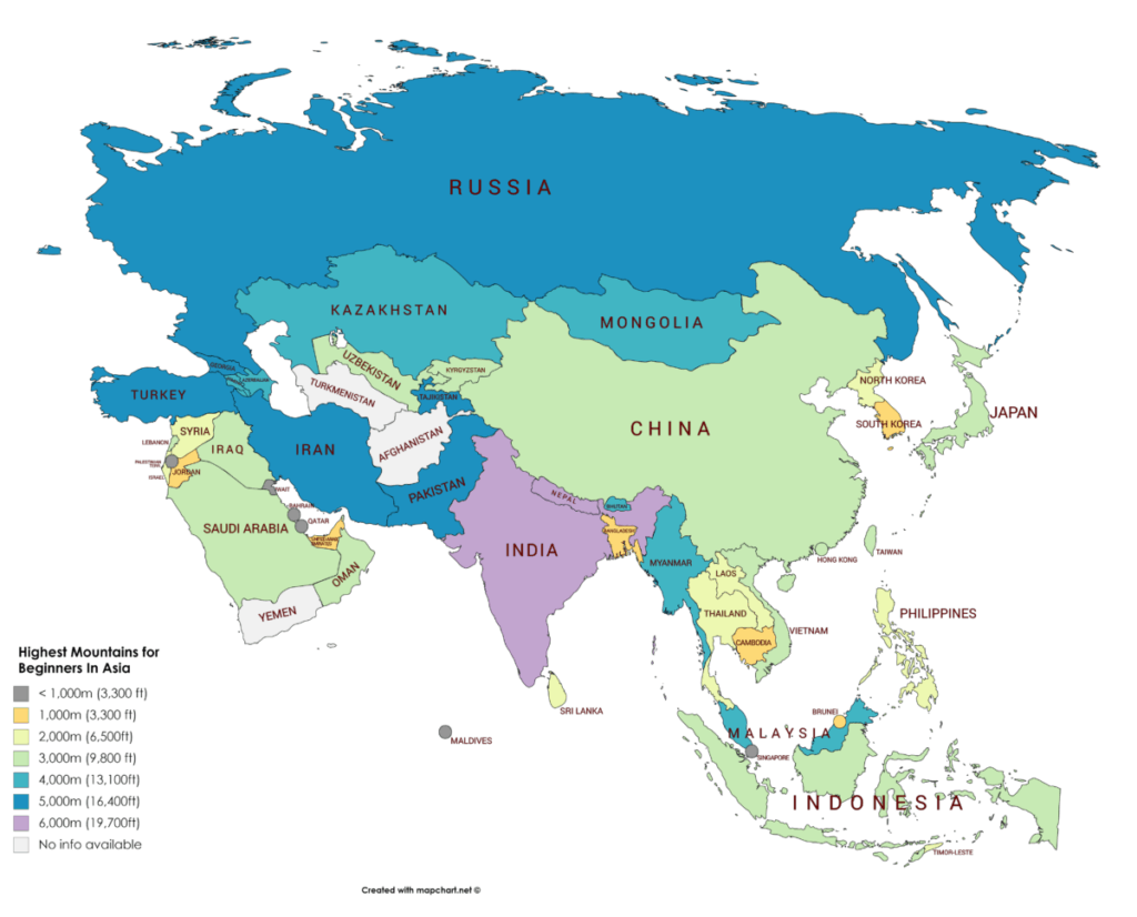
We all know that Mount Everest, the highest mountain in the world, is in Asia. But did you know that the top 100 highest mountains in the world are all in Asia?
Many of these highest peaks in Asia are technical climbs. Just the altitude alone will prove to be a challenge to many climbers. They are certainly too challenging for an inexperienced climber.
In many countries in Asia, mountain climbing may still be a relatively new sport. It can be quite difficult to find out information on them. Some areas may also be quite difficult to access because of a lack of infrastructure.
So I’ve put together this resource. It lists 74 of the highest peaks in Europe that beginners can attempt.
For more of the highest climbs around the world, check out:
- 56 Highest Mountains To Climb in the US for Beginners
- 56 Highest Mountains To Climb in Europe for Beginners
- 27 Highest Mountains To Climb in North America for Beginners
- 20 Highest Mountains To Climb in South America for Beginners
- 18 Highest Mountains To Climb in Africa for Beginners
But not all these climbs are easy! Some of the climbs are in high altitudes or have icy conditions. You should consider hiring a guide if you do not have the relevant experience or skills for the climbs.
- Before We Start…
- List Of Beginner Mountains To Climb In Asia
- Afghanistan
- Armenia
- Azerbaijan
- Bahrain
- Bangladesh
- Bhutan
- Brunei
- Cambodia
- China
- Cyprus
- Georgia
- India
- Indonesia
- Iran
- Iraq
- Israel
- Japan
- Jordan
- Kazakhstan
- Kuwait
- Kyrgyzstan
- Laos
- Lebanon
- Malaysia
- Maldives
- Mongolia
- Myanmar (formerly Burma)
- Nepal
- North Korea
- Oman
- Pakistan
- Palestine
- Philippines
- Qatar
- Russia
- Saudi Arabia
- Singapore
- South Korea
- Sri Lanka
- Syria
- Taiwan
- Tajikistan
- Thailand
- Timor-Leste
- Turkey
- Turkmenistan
- United Arab Emirates (UAE)
- Uzbekistan
- Vietnam
- Yemen
Before We Start…
Just a few things to note before jumping right into the list. It will be helpful for you to first understand a bit about some of the terminology used in the list. These are also terminology that you may have seen from other sources.
Thousanders
In Asia, the elevations of the mountains are typically referred to in meters.
The highest mountains are referred to as eight-thousanders. This means that they have an elevation of at least 8,000 meters (26,427 feet).
- Eight-thousanders: at least 8,000 meters (26,427 feet)
- Seven-thousanders: at least 7,000 meters (22,966 feet) but less than 8,000 meters
- Six-thousanders: at least 6,000 meters (19,685 feet) but less than 7,000 meters
- Five-thousanders: at least 5,000 meters (16,404 feet) but less than 6,000 meters
- Four-thousanders: at least 4,000 meters (13,123 feet) but less than 5,000 meters (16,404 feet)
- Three-thousanders: at least 3,000 meters (9,842 feet) but less than 4,000 meters
- Two-thousanders: at least 2,000 meters (6,561 feet) but less than 3,000 meters
- One-thousanders: at least 1,000 meters (3,281 feet) but less than 2,000 meters
What Is Summitpost?
I have provided a SummitPost link for each of the listed climbs below.
SummitPost is an online library of climbing information for mountains around the world.
The information is provided by a community of climbers. It can be a useful starting point to learn more about the mountains and climbs. However, do note that not all information is fully kept up to date or complete. It will be good to do additional research before your climbs.
Since it is a community-driven initiative, it will be great if you could highlight any errors or outdated information. You can do so in the comments section of the respective pages.
There are also other similar communities such as Hiking Project and Outdooractive.
Rating Systems
There are many rating systems that grades the difficulty of a climb.
Different grading systems are used for different types of climbing.
Different countries may also have their own grading systems.
However, there is no official adoption of any climbing grading or rating system in Asia.
There are a few grading systems used in this list:
Yosemite Decimal System (YDS)
- This is the grading system used widely in the US to rate the difficulty of a climb.
- Class 1 and 2 climbs are suitable for beginners.
- Beginners can attempt Class 3 climbs with a guide.
- Read more about YDS here.
International French Adjectival System (IFAS) aka Alpine Rating System
- This is the grading system used in Europe for climbing in alpine conditions.
- F and PD climbs can be suitable for beginners if the routes do not have any snow or ice.
- Beginners can attempt F and PD climbs in snowy or icy terrains with a guide.
- Read more about IFAS here.
Russian Grading System
- This is the grading system used mainly in post-Soviet states.
- Grade 1A climbs are suitable for beginners.
- Beginners can attempt Grades 1B, 2A, and 2B climbs with a guide or after some lessons or training.
- Read more about the Russian grading system here.
Difference Between Elevation And Elevation Gain
You may notice that the list below states both the elevation and elevation gained.
The elevation measures to the height of the summit above sea level.
The elevation gained is the difference in height from the start of the trail to the summit.
The elevation gained might be different between routes. This depends on the trailheads which may be at different points on the mountains.
Climbing Season Vs Best Time To Climb
For each of the climbs listed below, I have included the climbing season as well as the best time to climb.
Beginners should stick to the duration listed under the best time to climb.
Though climbing is still possible for the rest of the year, it is more suitable for experienced climbers.
The conditions are harsher and the climb’s difficulty rating also increases. Non-technical climbs can often turn into technical ones.
List Of Beginner Mountains To Climb In Asia
The highest mountain in Asia is also the highest mountain in the world — Mount Everest. Mount Everest stands at a height of 8,850 meters (29,035 feet).
Afghanistan
The highest peak in Afghanistan is a seven-thousander.
The highest peak in Afghanistan is Noshaq which stands at 7,492 meters (24,580 feet). The climb is technical and is not suitable for beginners.
Due to the political instability, there is limited information about climbing in Afghanistan.
Armenia
Armenia lies between Asia and Europe.
The highest peak in Armenia is a four-thousander. Armenia is home to just 1 four-thousander.
1. Mount Aragats (4,090 meters / 13,419 feet)
- The highest peak in Armenia.
- An extinct volcano with 2 frequently climbed peaks, the north and south summits.
- The North Summit is the highest point on Mount Aragats. The South Summit is an easier climb but it only reaches the height of 3,879 meters (12,727 feet).
- SummitPost page
- Hiking Project page
| Elevation (meters) | 4,090 |
| Elevation (feet) | 13,419 |
| Popular Routes | Starts from from Stone Lake |
| Rating | YDS Class 2 |
| Elevation Gain (meter) | 1,135 |
| Elevation Gain (feet) | 3,724 |
| Distance (km) | 8.5 |
| Distance (mi) | 5.3 |
| Climbing Season | All year |
| Best Time To Climb | Jun to Oct |
| Snow And/ Or Ice | All year |
| Permit Requirement | No |
2. Mount Azhdahak (3,597 meters / 11,801 feet)
- The third highest mount in Armenia.
- Views of surrounding mountains and a crater lake at the summit.
- Hiking Project page here and here.
| Elevation (meters) | 3,597 |
| Elevation (feet) | 11,801 |
| Popular Routes | Starts from Sevaberd village/ Lake Akna |
| Rating | YDS Class 1 |
| Elevation Gain (meter) | 1,581 |
| Elevation Gain (feet) | 5,187 |
| Distance (km) | 32 |
| Distance (mi) | 19.9 |
| Climbing Season | All year |
| Best Time To Climb | Jul to Sep |
| Snow And/ Or Ice | Most of the year |
| Permit Requirement | No |
3. Mount Khustup (3,214 meters / 10,545 feet)
- Though it is not in the top 10 highest peaks in Armenia, it is one of the most picturesque mountains in the country.
- Hiking Project page
| Elevation (meters) | 3,214 |
| Elevation (feet) | 10,545 |
| Popular Routes | Starts from Kapan City |
| Rating | YDS Class 1 |
| Elevation Gain (meter) | 2,117 |
| Elevation Gain (feet) | 6,946 |
| Distance (km) | 14.6 |
| Distance (mi) | 9.1 |
| Climbing Season | All year |
| Best Time To Climb | Jun to Oct |
| Snow And/ Or Ice | Winter |
| Permit Requirement | No |
Azerbaijan
Azerbaijan lies between Asia and Europe.
The highest peak in Azerbaijan is a four-thousander. Azerbaijan is home to 8 four-thousanders.
Although more than half of Azerbaijan’s land area is mountainous, climbing information is scarce.
Other than Mount Bazardüzü, there is very limited information available online. If you want more information, do contact the Azerbaijan Alpine Club or look for local guides.
4. Mount Bazardüzü (4,466 meters / 14,652 feet)
- Located in both Azerbaijan and Russia.
- The highest peak in Azerbaijan.
- Although the easiest route is not a technical climb, it is a glacier climb.
- A guide is mandatory for all climbs. Due to the current political situation, it might be easier to get a guide in Russia than in Azerbaijan.
- SummitPost page
- Blog article
| Elevation (meters) | 4,466 |
| Elevation (feet) | 14,652 |
| Popular Routes | South side |
| Rating | F |
| Elevation Gain (meter) | 1,666 |
| Elevation Gain (feet) | 5,466 |
| Duration | 1 to 2 days (distance unknown) |
| Climbing Season | All year |
| Best Time To Climb | Jul to Sep |
| Snow And/ Or Ice | All year |
| Permit Requirement | Yes |
5. Mount Shahdagh (4,243 meters/ 13,921 feet)
- Its castle-like shape led to its name “Shah Dag” which means the King of Mountains.
- The second highest peak in Azerbaijan. Technically the highest mountain located completely in Azerbaijan.
- Although the easiest route is not a technical climb, it is a glacier climb. Beginners should climb with a guide.
- There is limited information online. You can contact the Alpine Club or the local guides to get more information.
- Blog article
Bahrain
There are no high mountains to climb in Bahrain.
The highest peak in Bahrain is Jabal ad Dukhan at 134 meters (440 feet).
Bangladesh
The highest peak in Bangladesh is a one-thousander.
6. Saka Haphong (1,063 meters / 3,488 feet)
- Also known as Mowdok Taung or Tlang Moy.
- Located between Bangladesh and Myanmar.
- The highest peak in Bangladesh.
- The mountain is seldom climbed. There is very limited information online. You can contact local guides to get more information.
- Although it is not a technical climb, the mountain is remote. There are no marked trails. Beginners should climb with a guide.
- Blog articles here and here
| Elevation (meters) | 1,063 |
| Elevation (feet) | 3,488 |
| Popular Routes | Start from Boarding Para village |
| Rating | YDS Class 2 |
| Elevation Gain | Unknown |
| Duration | 4 days (distance unknown) |
| Route Type | Loop |
| Climbing Season | All year |
| Best Time | All year |
| Snow And/ Or Ice | No |
| Permit Requirement | Yes |
Bhutan
You will find that visiting Bhutan can be a difficult and costly affair. The government limits the number of tourists per year and you are required to pay a “daily fee” for your visit.
Besides, since the 1990s, climbing peaks above 6,000 meters (20,000 feet) is banned by the Bhutan government. The locals believe that the mountains are dwelling places for spirits.
When it comes to climbing the lower peaks, you will need to arrange all activities with a local agent.
The highest peak in Bhutan is a seven-thousander.
Gangkhar Puensum (7,570 meters / 24,840 feet) is the highest peak in Bhutan. It is possibly the highest unclimbed mountain in the world. Before the ban, climbers struggled with treacherous climbing conditions. There was also a lack of well-documented maps.
Here are some of the more popular mountains you can climb in Bhutan:
7. Jhomolhari Trek (4,890 meters / 16,043 feet)
- The most popular trek in Bhutan.
- The highest points in the trek include the Bhonte La Pass at 4,890 meters (16,043 feet) and Takhung La Pass at 4,520 meters (14,829 feet).
- Views of Mount Jomolhari, the third highest peak in Bhutan.
- Bhutan Tourism page
- Lonely Planet page
| Elevation (meters) | 4,890 |
| Elevation (feet) | 16,043 |
| Popular Routes | Start from Gunitsawa Village |
| Rating | YDS Class 2 |
| Elevation Gain (meter) | 2390 |
| Elevation Gain (feet) | 7,841 |
| Distance (kilometers) | 120 |
| Distance (miles) | 75 |
| Route Type | One-way |
| Climbing Season | Apr to Jun, Sep to Nov |
| Best Time | Apr, Oct |
| Snow And/ Or Ice | Nov to Mar |
| Permit Requirement | Yes |
8. Druk Path Trek (4,200 meters / 13,776 feet)
- The highest point in the trek reaches 4,200 meters (13,776 feet).
- Views of Gangkhar Puensum, the highest peak in Bhutan.
- Bhutan Tourism page
- SummitPost page
| Elevation (meters) | 4,200 |
| Elevation (feet) | 13,780 |
| Popular Routes | Start from Ta Dzong (National Museum) |
| Rating | YDS Class 2 |
| Elevation Gain (meter) | 1800 |
| Elevation Gain (feet) | 5,906 |
| Distance (kilometers) | 55 |
| Distance (miles) | 34 |
| Route Type | One-way |
| Climbing Season | Mar to Jun, Sep to Nov |
| Best Time | Apr, Oct |
| Snow And/ Or Ice | Nov to Mar |
| Permit Requirement | Yes |
9. Bumthang Owl Trek (3,600 meters / 11,811 feet)
- One of the shorter treks in Bhutan.
- The highest point in the trek is Drangela Pass at 3,600 meters (11,811 feet).
- Views of Gangkhar Puensum, the highest peak in Bhutan.
- Bhutan Tourism page
| Elevation (meters) | 3,600 |
| Elevation (feet) | 11,811 |
| Popular Routes | Start from Manchugang |
| Rating | YDS Class 1 |
| Elevation Gain (meter) | 1350 |
| Elevation Gain (feet) | 4,429 |
| Distance (kilometers) | 14 to 17 |
| Distance (miles) | 8.5 to 10.5 |
| Route Type | One-way |
| Climbing Season | Mar to Jun, Nov to Dec |
| Best Time | Apr to Jun |
| Snow And/ Or Ice | Dec to Feb |
| Permit Requirement | Yes |
Brunei
The highest peak in Brunei is a one-thousander.
10. Bukit Pagon (1,850 meters / 6,070 feet)
- Located on the border between Brunei and Malaysia.
- The highest peak in Brunei.
- There is very limited information online. You can contact local guides to get more information.
- Although it is not a technical climb, the mountain is remote. There are no marked trails. Beginners should climb with a guide.
- Blog article here.
| Elevation (meters) | 1,850 |
| Elevation (feet) | 6,070 |
| Popular Routes | Start from the base camp near Limbang Town |
| Rating | YDS Class 2 to 3 UIAA Grade I to II |
| Elevation Gain (meter) | 988 |
| Elevation Gain (feet) | 3,241 |
| Distance (kilometers) | 19 |
| Distance (miles) | 12 |
| Route Type | Loop |
| Climbing Season | All year |
| Best Time | All year |
| Snow And/ Or Ice | No |
| Permit Requirement | No |
Cambodia
The highest peak in Cambodia is a one-thousander.
11. Phnom Aural (1,813 meters / 5,948 feet)
- The highest peak in Cambodia.
- There are no views at the top except for a Buddhist shrine with a summit marker.
- There is very limited information online. You can contact local guides to get more information.
- Although it is not a technical climb, the mountain is remote. There are no marked trails. Beginners should climb with a guide.
- Blog article here.
| Elevation (meters) | 1,813 |
| Elevation (feet) | 5,948 |
| Popular Routes | Start from Srae Kan Bei Village |
| Rating | YDS Class 2 |
| Elevation Gain (meter) | 1,613 |
| Elevation Gain (feet) | 5,292 |
| Duration | 2 to 3 days (distance unknown) |
| Route Type | Loop |
| Climbing Season | All year |
| Best Time | All year |
| Snow And/ Or Ice | No |
| Permit Requirement | Agreement from village head at Srae Kan Bei Village |
China
The highest mountains in China are also some of the highest mountains in the world.
China is home to Mount Everest (8,850 meters / 29,035 feet), K2 (8,611 meters/ 28,251 feet), and Mount Lhotse (8,516 meters/ 27,940 feet). They are the highest, second highest and fourth highest mountains in the world respectively.
Due to the high altitudes, many of China’s highest peaks are not suitable for beginners.
Here are some of the popular peaks that beginners can climb:
12. Emeishan (3,099 meters / 10,167 feet)
- Also known as Mount Emei.
- The highest peak of the Four Sacred Mountains of Buddhism.
- You can find many temples on the mountain.
- You can find monasteries from the Ming and Qing dynasties at the summit.
- You can also take a cable car to the summit.
- SummitPost page
| Elevation (meters) | 3,099 |
| Elevation (feet) | 10,167 |
| Popular Routes | Start from Baoguo Si |
| Rating | YDS Class 1 |
| Elevation Gain (meter) | 2,549 |
| Elevation Gain (feet) | 8,363 |
| Distance (kilometers) | 80 |
| Distance (miles) | 50 |
| Route Type | Loop |
| Climbing Season | All year |
| Best Time | Mar to Oct |
| Snow And/ Or Ice | Winter |
| Permit Requirement | No |
13. Wutaishan (3,061 meters / 10,043 feet)
- Also known as Mount Wutai.
- One of the Four Sacred Mountains of Buddhism.
- There are 5 peaks on the mountain. The nothern peak is the highest.
- The common route covers all 5 peaks in the clockwise direction. Pilgrims follow the clockwise direction according to Buddhist traditions.
- You can find many temples on the mountain.
- You can also take a cable car to the summit.
- Blog article
| Elevation (meters) | 3,061 |
| Elevation (feet) | 10,043 |
| Popular Routes | Start from Mount WuTai base camp |
| Rating | YDS Class 1 |
| Elevation Gain | Unknown |
| Distance (kilometers) | 55 |
| Distance (miles) | 34 |
| Route Type | Loop |
| Climbing Season | All year |
| Best Time | Mar to Oct |
| Snow And/ Or Ice | Winter |
| Permit Requirement | No |
14. Huangshan (1,864 meters / 6,115 feet)
- Also known as Yellow Mountain.
- One of the Three Famous Mountains in China.
- You can also take a cable car to the summit.
- SummitPost page
- Information about the routes here
| Elevation (meters) | 1,864 |
| Elevation (feet) | 6,115 |
| Popular Routes | West Sea Grand Canyon Route |
| Rating | YDS Class 1 |
| Elevation Gain (meter) | 400 |
| Elevation Gain (feet) | 1,312 |
| Distance (kilometers) | 9 |
| Distance (miles) | 6 |
| Route Type | Loop |
| Climbing Season | All year |
| Best Time | Apr, May, Sep, Oct |
| Snow And/ Or Ice | No |
| Permit Requirement | No |
Cyprus
Cyprus lies between Asia and Europe.
The highest peak in Cyprus is a one-thousander.
15. Mount Olympus (1,952 meters / 6,404 feet)
- Not to be confused with the Mount Olympus in Greece. Or the other one in Washington, US.
- The highest peak in Cyprus.
- The highest point you can climb to is a couple of meters below the actual summit. You cannot go any further due to the military presence.
- SummitPost page
| Elevation (meters) | 1,952 |
| Elevation (feet) | 6,404 |
| Popular Routes | Kaledonia Trail |
| rating | YDS Class 1 |
| Elevation Gain (meter) | 752 |
| Elevation Gain (feet) | 2,467 |
| Distance (km) | 20 |
| Distance (mi) | 12.4 |
| Climbing Season | All year |
| Best Time To Climb | All year |
| Snow And/ Or Ice | Winter |
| Permit Requirement | No |
Georgia
Georgia lies between Asia and Europe.
Many of Georgia’s highest peaks are found in the Greater Caucasus Mountain Range. The range lies on the border between Georgia and Russia.
The highest peak in Georgia is Mount Shkhara which stands at 5,068 meters (17,037 feet). It is considered one of the most challenging climbs in Europe.
Other than Mount Kazbek, many of the five-thousanders and four-thousanders in Georgia are technical glacier climbs. They are not suitable for beginners:
16. Mount Kazbek (5,033 meters / 16,512 feet)
- Located in both Georgia and Russia.
- The third highest peak in Georgia and the only five-thousander suitable for beginners.
- An extinct volcano.
- Although it is less challenging climb than the other Georgia’s five-thousanders, it is still a glacier climb. There is a short section of easy ice climbing near the summit. Beginners should climb with a guide.
- SummitPost page
- Information on the normal route
| Elevation (meters) | 5,033 |
| Elevation (feet) | 16,512 |
| Popular Routes | Normal route |
| Rating | PD |
| Elevation Gain (meter) | 3,293 |
| Elevation Gain (feet) | 10,804 |
| Duration | 4 to 5 days (distance unknown) |
| Climbing Season | All year |
| Best Time To Climb | Jun to Sep |
| Snow And/ Or Ice | All year |
| Permit Requirement | No |
India
The highest peak in India is eight-thousander Kangchenjunga (8,586 meters / 28,169 feet). It is also the world’s third highest mountain.
India only has one eight-thousander but close to 40 seven-thousanders.
Due to the high altitudes, many of India’s highest peaks are not suitable for beginners.
Here are some of the popular peaks that beginners can climb:
17. Stok Kangri (6,151 meters / 20,182 feet)
- One of the toughest climb on this list. It is a good introduction into high altitude mountaineering.
- Although the easiest route is not a technical climb, it is a high altitude glacier climb. Beginners should climb with a guide.
- SummitPost page
- Blog article here and here
| Elevation (meters) | 6,151 |
| Elevation (feet) | 20,182 |
| Popular Routes | Start from Stok Village |
| Rating | YDS Class 3 PD |
| Elevation Gain (meter) | 2,627 |
| Elevation Gain (feet) | 8,620 |
| Distance (kilometers) | 40 |
| Distance (miles) | 25 |
| Route Type | Loop |
| Climbing Season | Apr to Oct |
| Best Time | Jun to Sep |
| Snow And/ Or Ice | All year |
| Permit Requirement | Yes |
18. Mount Kanamo (5,974 meters / 19,600 feet)
- Although the route is not a technical climb, Mount Kanamo is a high altitude climb with ice and snow near the top. Beginners should climb with a guide.
- Blog article here and here
| Elevation (meters) | 5,974 |
| Elevation (feet) | 19,600 |
| Popular Routes | Start from Kibber Village |
| Rating | YDS Class 3 PD |
| Elevation Gain (meter) | 1,674 |
| Elevation Gain (feet) | 5,492 |
| Distance (kilometers) | 27 |
| Distance (miles) | 17 |
| Route Type | Loop |
| Climbing Season | Apr to Oct |
| Best Time | Jun to Oct |
| Snow And/ Or Ice | All year |
| Permit Requirement | Yes |
19. Shrikhand Mahadev (5,227 meters / 17,149 feet)
- One of the toughest pilgrimage in India.
- Views of Kinnar Kailash, the mythical home of Shiva.
- Although the route is not a technical climb, the top of Shrikhand Mahadev has ice and snow. Beginners should climb with a guide.
- Blog article here and here
| Elevation (meters) | 5,227 |
| Elevation (feet) | 17,149 |
| Popular Routes | Start from Jaon Village |
| Rating | YDS Class 2 to 3 |
| Elevation Gain (meter) | 3,651 |
| Elevation Gain (feet) | 11,978 |
| Distance (kilometers) | 70 |
| Distance (miles) | 43 |
| Route Type | Loop |
| Climbing Season | Apr to Oct |
| Best Time | Jun to Aug |
| Snow And/ Or Ice | All year |
| Permit Requirement | No |
Indonesia
The highest peak in Indonesia is a four-thousander.
The highest peak in Indonesia is Puncak Jaya (also known as Carstensz Pyramid). It stands at 4,884 meters (16,024 feet). The climb is a technical climb and is not suitable for beginners.
There are three four-thousanders in Indonesia and they are not suitable for beginners.
Here are some of the highest peaks in Indonesia suitable for beginners:
20. Gunung Kerinci (3,805 meters / 12,484 feet)
- The highest volcano in South East Asia.
- An active volcano with its last eruption in 1970.
- SummitPost Page
| Elevation (meters) | 3,805 |
| Elevation (feet) | 12,484 |
| Popular Routes | Start from the forest trail 5km from Kersik Tua |
| Rating | YDS Class 2 |
| Elevation Gain (meter) | 2,305 |
| Elevation Gain (feet) | 7,562 |
| Distance (kilometers) | 17 |
| Distance (miles) | 11 |
| Route Type | Loop |
| Climbing Season | All year |
| Best Time | Apr to Sep |
| Snow And/ Or Ice | No |
| Permit Requirement | Fee payment |
21. Gunung Rinjani (3,726 meters / 12,224 feet)
- An active volcano with its last eruption in 2009.
- Views of a crater lake and surrounding volcanoes and islands.
- SummitPost Page
| Elevation (meters) | 3,726 |
| Elevation (feet) | 12,224 |
| Popular Routes | from Sembalun Lawang on the eastern side |
| Rating | YDS Class 2 |
| Elevation Gain (meter) | 2,570 |
| Elevation Gain (feet) | 8,432 |
| Distance (kilometers) | 24 |
| Distance (miles) | 15 |
| Route Type | One-way |
| Climbing Season | Apr to Dec |
| Best Time | Apr to Nov |
| Snow And/ Or Ice | No |
| Permit Requirement | Fee payment |
22. Gunung Semeru (3,676 meters / 12,060 feet)
- An active volcano and one of the most active in Indonesia. There are small eruptions happening every 20 minutes.
- Views of the surrounding volcanoes and the seas.
- SummitPost Page
| Elevation (meters) | 3,676 |
| Elevation (feet) | 12,060 |
| Popular Routes | Starts from Ranupane Village |
| Rating | YDS Class 2 |
| Elevation Gain (meter) | 1,676 |
| Elevation Gain (feet) | 5,499 |
| Distance (kilometers) | 30 |
| Distance (miles) | 19 |
| Route Type | Loop |
| Climbing Season | Apr to Dec |
| Best Time | Apr to Nov |
| Snow And/ Or Ice | No |
| Permit Requirement | Yes |
Iran
The highest peak in Iran is a five-thousander.
23. Damavand (5,609 meters / 18,403 feet)
- The highest peak in Iran.
- The highest volcano in Asia.
- A dormant volcano.
- Views of the surrounding mountains, valleys, and deserts.
- SummitPost page
- Blog article here
| Elevation (meters) | 5,609 |
| Elevation (feet) | 18,403 |
| Popular Routes | Southern face |
| Rating | YDS Class 2 |
| Elevation Gain (meter) | 2,609 |
| Elevation Gain (feet) | 8,560 |
| Distance (kilometers) | 16 |
| Distance (miles) | 10 |
| Route Type | Loop |
| Climbing Season | All year |
| Best Time | Jun to Sep |
| Snow And/ Or Ice | Winter |
| Permit Requirement | Yes |
24. Alam Kooh (4,851 meters / 15,915 feet)
- The second highest peak in Iran.
- The most challenging climb among the top 3 highest peaks in Iran.
- SummitPost Page
| Elevation (meters) | 4,851 |
| Elevation (feet) | 15,915 |
| Popular Routes | Hesarchal route via Marjikesh |
| Rating | YDS Class 3 |
| Elevation Gain (meter) | 2,551 |
| Elevation Gain (feet) | 8,369 |
| Distance (kilometers) | 27 |
| Distance (miles) | 17 |
| Route Type | Loop |
| Climbing Season | All year |
| Best Time | Jun to Oct |
| Snow And/ Or Ice | Winter |
| Permit Requirement | No |
25. Sabalan (4,811 meters / 15,784 feet)
- The third highest peak in Iran.
- An extinct volcano.
- View of a unique Eagle statue rock formation.
- SummitPost Page
| Elevation (meters) | 4,811 |
| Elevation (feet) | 15,784 |
| Popular Routes | Start Ghotoorsoo or Shabil towards the eastern shelter |
| Rating | YDS Class 1 |
| Elevation Gain (meter) | 1,111 |
| Elevation Gain (feet) | 3,645 |
| Distance (kilometers) | 20 |
| Distance (miles) | 12 |
| Route Type | Loop |
| Climbing Season | All year |
| Best Time | Jun to Sep |
| Snow And/ Or Ice | Winter |
| Permit Requirement | No |
Iraq
The highest peak in Iraq is a three-thousander.
Due to the country’s political instability and lack of infrastructure, very few climbers attempt to summit the mountains in Iraq.
Other than the two highest peaks listed below, there is very little information about the other mountains in Iraq.
26. Cheekha Dar (3,611 meters / 11,847 feet)
- Located on the border between Iran and Iraq.
- Although the route is not a technical climb, the top of Cheekha Dar has ice and snow. Beginners should climb with a guide. Guides are also recommended due to the presence of the military, rebels, and smugglers.
- The mountain is rarely climbed.
- SummitPost Page
- Blog article here
| Elevation (meters) | 3,611 |
| Elevation (feet) | 11,847 |
| Popular Routes | Start from Gundah Zhur village |
| Rating | YDS Class 2 to 3 |
| Elevation Gain (meter) | 2,011 |
| Elevation Gain (feet) | 6,598 |
| Duration | 17 hours (distance unknown) |
| Route Type | Loop |
| Climbing Season | All year |
| Best Time | All year |
| Snow And/ Or Ice | Winter |
| Permit Requirement | No |
27. Mount Halgurd (3,607 meters / 11,834 feet)
- The second highest peak in Iraq and the highest peak that is located entirely in Iraq.
- Although the easiest route is not a technical climb, it is a glacier climb. Beginners should climb with a guide.
- There is very limited information online. You can contact local guides to get more information.
- Blog article here
| Elevation (meters) | 3,607 |
| Elevation (feet) | 11,834 |
| Popular Routes | Start from the base camp near Choman |
| Rating | PD |
| Elevation Gain | Unknown |
| Duration | 2 to 4 days(distance unknown) |
| Route Type | Loop |
| Climbing Season | All year |
| Best Time | All year |
| Snow And/ Or Ice | All year |
| Permit Requirement | No |
Israel
The highest peak in Israel is a two-thousander.
28. Mount Hermon (2,814 meters / 9,232 feet)
- Located on the border between Lebanon, Syria, and Israel.
- The highest peak in Israel and Syria.
- Mount Hermon has a peak known as Har Habtarim. It is believed to be the spot where God promised Abraham that the Land of Israel would belong to his descendants. The spot is marked by an ancient tomb and huge oak trees.
- Views of the surrounding mountains and southern Lebanon.
- There is limited information online. You can local guides to get more information.
- Information on Mount Hermon here
- Alternatively, you can also take ski lifts to the summit and take the Golan Hiking Trail. The trail is 125 kilometers (78 miles) long.
Japan
The highest peak in Japan is a three-thousander.
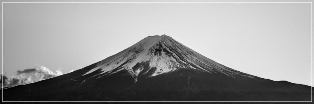
29. Mount Fuji (3,776 meters / 12,388 feet)
Thinking of climbing Mount Fuji? Find out more about the duration, how much it cost, when is the best time to visit and what you should wear.
- The highest peak in Japan.
- An active volcano that last erupted in 1707.
- One of the most climbed mountains in the world.
- Together with Yushan and Mount Kinabalu, these 3 mountains form the Asian Trilogy.
- Official site
- SummitPost page
| Elevation (meters) | 3,776 |
| Elevation (feet) | 12,388 |
| Popular Routes | Yoshida Trail |
| Rating | YDS Class 1 |
| Elevation Gain (meter) | 2300 |
| Elevation Gain (feet) | 7,546 |
| Distance (kilometers) | 13 |
| Distance (miles) | 8 |
| Route Type | Loop |
| Climbing Season | All year |
| Best Time | Jul to Sep |
| Snow And/ Or Ice | Nov to Jun |
| Permit Requirement | No |
30. Mount Kita-dake (3,193 meters / 10,476 feet)
- The second highest peak in Japan.
- The highest peak of the Shirane Sanzan or Three White Peaks. The other 2 peaks in the trio are Mount Aino-dake and Mount Notori. It is common to conquer Mount Aino-dake on the same trip.
- Views of Mount Fuji.
- Official site
- SummitPost page
- Blog article here and here
| Elevation (meters) | 3,193 |
| Elevation (feet) | 10,476 |
| Popular Routes | Start from Hirogawara |
| Rating | YDS Class 2 |
| Elevation Gain (meter) | 1700 |
| Elevation Gain (feet) | 5,577 |
| Distance (kilometers) | 24.5 (with Mount Aino-dake) |
| Distance (miles) | 15 |
| Route Type | One-way |
| Climbing Season | All year |
| Best Time | Jun to Oct |
| Snow And/ Or Ice | Nov to Jun |
| Permit Requirement | No |
31. Mount Okuhotaka-dake (3,190 meters / 10,466 feet)
- The third highest peak in Japan.
- Although it is not a technical climb, it is the most challenging among the 3 highest peaks. This is due to a section named Daikiretto. It requires climbing on a vertical section of rock (there are ropes, chains, and ladders in place).
- Official site
- SummitPost page
- Blog article here and here
| Elevation (meters) | 3,190 |
| Elevation (feet) | 10,466 |
| Popular Routes | Start from Kamikouchi |
| Rating | YDS Class 3 |
| Elevation Gain (meter) | 1685 |
| Elevation Gain (feet) | 5,528 |
| Distance (kilometers) | 36 |
| Distance (miles) | 22 |
| Route Type | Loop |
| Climbing Season | All year |
| Best Time | Jun to Oct |
| Snow And/ Or Ice | Nov to Jun |
| Permit Requirement | No |
Jordan
The highest peak in Jordan is a one-thousander.
32. Jabal Umm ad Dami (1,854 meters/ 6,083 feet)
- The highest peak in Jordan.
- View of the deserts and Saudi Arabia.
- Although the route is not a technical climb, the area is very remote with no proper trails. Beginners should climb with a guide.
- Blog article here and here
| Elevation (meters) | 1,854 |
| Elevation (feet) | 6,083 |
| Popular Routes | Start from Wadi Rum Village |
| Rating | YDS Class 2 to 3 |
| Elevation Gain | Unknown |
| Duration | 3 to 5 hours* (distance unknown) |
| Route Type | Loop |
| Climbing Season | All year |
| Best Time | All year |
| Snow And/ Or Ice | No |
| Permit Requirement | No |
*This is the duration of the actual climb. It excludes acclimatization days.
Kazakhstan
Kazakhstan lies between Asia and Europe.
Kazakhstan is home to 1 seven-thousander and 3 four-thousanders. The highest peak in Kazakhstan is Khan Tengri which stands at 7,010 meters (22,999 feet). It is a technical climb and not suitable for beginners.
Other than Belukha, there is very limited information online on the other four-thousanders.
Belukha (4,506 meters / 14,783 feet)
- Located between Kazakhstan, Russia, Mongolia, and China.
- The third highest peak in Kazakhstan.
- The mountain has 2 summits — the east and west summit.
- The east summit is an easier climb. The route starts from Russia (see number 54 below).
Kuwait
There are no high mountains to climb in Kuwait.
The highest peak in Kuwait is Mutla Ridge at 306 meters (1,004 feet).
Kyrgyzstan
The highest peak in Kyrgyzstan is a seven-thousander Jengish Chokusu. It stands at a height of 7,439 meters (24,406 feet).
Kyrgyzstan is home to 3 seven-thousanders.
In the Old Soviet Union, there are 5 Snow Leopard mountains. These are mountains which are taller than 7,000 meters (23,000 feet). Conquering all 5 of these mountains will give you the coveted title of a “Snow Leopard”.
3 of these Snow Leopard mountains are in Kyrgyzstan.
All Snow Leopard mountains are challenging technical climbs in high altitudes and icy conditions. They are not suitable for beginners.
Here are some of the highest peaks in Kyrgyzstan suitable for beginners:
33. Ala-Kul Trek (3,800 meters / 12,467 feet)
- The highest point in the trek is Ala-Kul Pass at 3,800 meters (12,467 feet). This overlooks the scenic Ala-Kul Lake.
- One of the more popular treks in the area.
- The trek goes through the Tian Shan Mountains in eastern Kyrgyzstan.
- Blog article here and here.
| Elevation (meters) | 3,800 |
| Elevation (feet) | 12,467 |
| Popular Routes | Start from Ala-Kul nature reserve |
| Rating | YDS Class 2 |
| Elevation Gain | Unknown |
| Distance (kilometers) | 45 |
| Distance (miles) | 28 |
| Route Type | One-way |
| Climbing Season | Jun to Sep |
| Best Time | Jul to Aug |
| Snow And/ Or Ice | Winter |
| Permit Requirement | No |
34. Kyzyl Suu-Jeti Oguz trek (3,800 meters / 12,467 feet)
- The highest point in the trek is Archa Tör Pass at 3,800 meters (12,467 feet).
- The trek goes through the Tian Shan Mountains in eastern Kyrgyzstan.
- Views of snow-covered mountains in the region.
- Blog article here
| Elevation (meters) | 3,800 |
| Elevation (feet) | 12,467 |
| Popular Routes | Start from Kyzyl Suu |
| Rating | YDS Class 2 |
| Elevation Gain (meter) | 2,300 |
| Elevation Gain (feet) | 7,546 |
| Distance (kilometers) | 50 |
| Distance (miles) | 31 |
| Route Type | One-way |
| Climbing Season | Jun to Sep |
| Best Time | Jun to Jul |
| Snow And/ Or Ice | Winter |
| Permit Requirement | No |
35. Jyrgalan Boz Uchuk Lakes Trek (3,515 meters / 11,532 feet)
- The highest point in the trek reaches 3,515 meters (11,532 feet).
- The trek goes through the Tian Shan Mountains in eastern Kyrgyzstan.
- Views of snow-covered mountains in the region.
- Blog article here
| Elevation (meters) | 3,515 |
| Elevation (feet) | 11,532 |
| Popular Routes | Start from Jyrgalan town |
| Rating | YDS Class 2 |
| Elevation Gain (meter) | 1,255 |
| Elevation Gain (feet) | 4,117 |
| Distance (kilometers) | 55 |
| Distance (miles) | 34 |
| Route Type | One-way |
| Climbing Season | Jun to Sep |
| Best Time | Jun to Jul |
| Snow And/ Or Ice | Winter |
| Permit Requirement | No |
Laos
The highest peak in Laos is a two-thousander.
The highest peak in Laos in Phou Bia which stands at 2,819 meters (9,249 feet). However, the mountain is a restricted area and climbing is not allowed. There are many unexploded landmines in the area.
36. Phu Xai Lai Leng (2,720 meters / 8,924 feet)
- Located on the border of Laos and Vietnam.
- The second highest peak in Laos.
- There is very limited information online. You can contact local guides to get more information.
- It seems more common for the tours to be organized from the Vietnam side. I found one tour here.
Lebanon
The highest peak in Lebanon is a three-thousander.
Other than Qurnat as Sawda, there is very limited information available online about other peaks in Lebanon.
37. Qurnat as Sawda (3,088 meters / 10,131 feet)
- The highest peak in Lebanon.
- There is very limited information online. You can contact local guides to get more information.
- Although the route is not a technical climb, the area is very remote with no proper trails. Beginners should climb with a guide.
- According to religious literature, the peak is believed to be where Noah replanted a sacred tree after the flood in the Bible.
- Blog articles here and here.
| Elevation (meters) | 3,088 |
| Elevation (feet) | 10,131 |
| Popular Routes | Start from Cedar’s Ski Resort |
| Rating | YDS Class 2 to 3 F |
| Elevation Gain (meter) | 1,088 |
| Elevation Gain (feet) | 3,570 |
| Distance (kilometers) | 24 |
| Distance (miles) | 15 |
| Route Type | Loop |
| Climbing Season | Apr to Oct |
| Best Time | Jul to Aug |
| Snow And/ Or Ice | Winter |
| Permit Requirement | No |
Malaysia
The highest peak in Malaysia is a four-thousander. Malaysia only has one four-thousander and has no three-thousanders.
38. Mount Kinabalu (4,095 meters / 13,435 feet)
- The highest peak in Malaysia.
- Although the route is not a technical climb, a guide is required by regulations.
- Together with Mount Fuji and Yushan, these 3 mountains form the Asian Trilogy.
- Official site
- SummitPost page
- Blog article here
| Elevation (meters) | 4,095 |
| Elevation (feet) | 13,435 |
| Popular Routes | Ranau Trail |
| Rating | YDS Class 1 |
| Elevation Gain (meter) | 2,500 |
| Elevation Gain (feet) | 8,202 |
| Distance (kilometers) | 18 |
| Distance (miles) | 11 |
| Route Type | Loop |
| Climbing Season | All year |
| Best Time | Mar to Apr |
| Snow And/ Or Ice | No |
| Permit Requirement | Yes |
39. Mount Trusmadi (2,642 meters / 8,668 feet)
- The second highest peak in Malaysia.
- Though it is a lower peak, it is a more challenging climb than Mount Kinabalu.
- Blog article here and here.
| Elevation (meters) | 2,642 |
| Elevation (feet) | 8,668 |
| Popular Routes | Kaingaran Trail |
| Rating | YDS Class 3 |
| Elevation Gain (meter) | 1,016 |
| Elevation Gain (feet) | 3,333 |
| Distance (kilometers) | 10 |
| Distance (miles) | 6 |
| Route Type | Loop |
| Climbing Season | All year |
| Best Time | Mar to Apr |
| Snow And/ Or Ice | No |
| Permit Requirement | Yes |
40. Mount Tambuyukon (2,579 meters / 8,461 feet)
- The third highest peak in Malaysia.
- Though it is a lower peak, it is a more challenging climb than Mount Kinabalu.
- Official site
- Blog article
| Elevation (meters) | 2,579 |
| Elevation (feet) | 8,461 |
| Popular Routes | Southern entry in Monggis Substation |
| Rating | YDS Class 3 |
| Elevation Gain (meter) | 2,312 |
| Elevation Gain (feet) | 7,585 |
| Distance (kilometers) | 14 |
| Distance (miles) | 9 |
| Route Type | Loop |
| Climbing Season | All year |
| Best Time | Mar to Apr |
| Snow And/ Or Ice | No |
| Permit Requirement | Yes |
Maldives
Maldives is the flattest country in the world. There are no high mountains to climb in Maldives.
The highest peak in Maldives is an unspecified location on Villingilli Island in Addu Atoll at just 2.4 meters (7.9 feet). This is the lowest country’s high-point in the world.
Mongolia
The highest peak in Mongolia is a four-thousander.
Other than Mount Khüiten, there is very limited information available online about other peaks in Mongolia.
41. Mount Khüiten (4,374 meters / 14,350 feet)
- The highest peak in Mongolia.
- Although the easiest route is not a technical climb, it is a glacier climb. Beginners should climb with a guide.
- SummitPost page
- Blog article here
| Elevation (meters) | 4,374 |
| Elevation (feet) | 14,350 |
| Popular Routes | Start from the Oigor river valley |
| Rating | PD |
| Elevation Gain | Unknown |
| Duration | 6 to 7 days (distance unknown) |
| Route Type | Loop |
| Climbing Season | All year |
| Best Time | Jun to Aug |
| Snow And/ Or Ice | All year |
| Permit Requirement | No |
Myanmar (formerly Burma)
The highest peak in Myanmar is a five-thousander.
The highest peak in Myanmar is Hkakabo Razi which stands at 5,881 meters (19,295 feet). Hkakabo Razi is said to be a tougher climb than Mount Everest.
Many of the highest peaks in Myanmar are not suitable for beginners.
Here are some of the highest peaks in Myanmar suitable for beginners:
42. Phonyin Razi (4,282 meters / 14,049 feet)
- Views of the Himalaya in India and Myanmar.
- Although the easiest route is not a technical climb, it is a glacier climb with no proper trails. Beginners should climb with a guide.
- Blog article here
| Elevation (meters) | 4,282 |
| Elevation (feet) | 14,049 |
| Popular Routes | Start from Shangaung Village |
| Rating | YDS Class 2 |
| Elevation Gain (meter) | 3,840 |
| Elevation Gain (feet) | 12,599 |
| Duration | 10 days (distance unknown) |
| Route Type | Loop |
| Climbing Season | Nov to May |
| Best Time | Nov to May |
| Snow And/ Or Ice | All year |
| Permit Requirement | No |
43. Phon Kan Razi (3,660 meters / 12,008 feet)
- One of the more popular and easier climbs in Myanmar.
- Views of the surrounding mountains in India and China.
| Elevation (meters) | 3,660 |
| Elevation (feet) | 12,008 |
| Popular Routes | Start from Putao |
| Rating | YDS Class 1 |
| Elevation Gain (meter) | Unknown |
| Duration | 10 days (distance unknown) |
| Route Type | Loop |
| Climbing Season | Oct to Apr |
| Best Time | Oct to Apr |
| Snow And/ Or Ice | Apr to Sep |
| Permit Requirement | No |
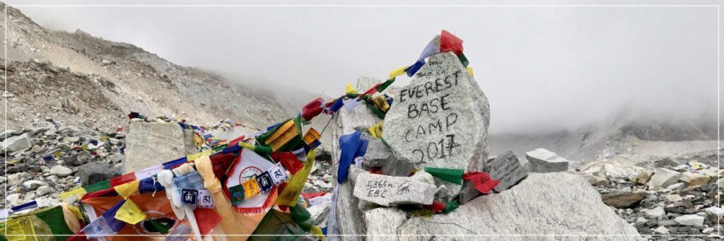
Nepal
Nepal is home to the world’s highest mountain — eight-thousander Mount Everest. It stands at a height of 8,848 meters (29,029 feet).
Nepal has 8 eight-thousanders. This is more than half of the world’s 14 eight-thousanders.
Due to the high altitudes, many of Nepal’s highest peaks are not suitable for beginners. On the plus side, there are plenty of trekking peaks for beginners.
Here are some of the highest peaks in Nepal suitable for beginners:
44. Mera Peak (6,476 meters / 21,246 feet)
- Not to be confused with India’s Meru Peak (6,660 meters/ 21,850 feet). Meru Peak is the star of the 2015 award-winning documentary Meru.
- The highest non-technical peak in Nepal.
- Views of the surrounding eight-thousanders, lush forests and Himalayan villages.
- Though the climb is non-technical, you will still need to use some climbing equipment. Beginners should climb with a guide.
- SummitPost page
| Elevation (meters) | 6,476 |
| Elevation (feet) | 21,246 |
| Popular Routes | Start from the north side |
| Rating | PD |
| Elevation Gain | Depends on route |
| Duration | 3 days* (distance depends on route) |
| Route Type | Depends on route |
| Climbing Season | All year |
| Best Time | Mar to May, Sep to Nov |
| Snow And/ Or Ice | All year |
| Permit Requirement | Yes |
*This is the duration of the actual climb. It excludes acclimatization days.
45. Island Peak (6,189 meters / 20,305 feet)
- Also known as Imja Tse.
- One of the most climbed high peaks in Nepal.
- Views of the surrounding peaks including Mount Everest.
- You can even visit the Everest base camp as part of the expedition.
- Although it is not a technical climb, it is a high altitude glacier climb. Beginners should climb with a guide.
- SummitPost page
| Elevation (meters) | 6,189 |
| Elevation (feet) | 20,305 |
| Popular Routes | Start from trail towards Chhukhung |
| Rating | PD |
| Elevation Gain | Depends on route |
| Duration | 1 to 2 days* (distance depends on route) |
| Route Type | Depends on route |
| Climbing Season | All year |
| Best Time | Apr to May, Oct to Nov |
| Snow And/ Or Ice | All year |
| Permit Requirement | Yes |
*This is the duration of the actual climb. It excludes acclimatization days.
46. Lobuche East Peak (5,545 meters / 18,192 feet)
- Lobuche has an East and West Peak. The West Peak is a technical climb.
- Views of the surrounding peaks including Mount Everest.
- The route passes through the Everest base camp.
- Though it is lower than Mera and Island Peaks, it is a tougher climb.
- SummitPost page
| Elevation (meters) | 5,545 |
| Elevation (feet) | 18,192 |
| Popular Routes | Start from base camp towards South East Ridge |
| Rating | PD+ |
| Elevation Gain | Depends on route |
| Duration | 3 days* (distance depends on route) |
| Route Type | Depends on route |
| Climbing Season | All year |
| Best Time | Mar to May, Oct to Dec |
| Snow And/ Or Ice | All year |
| Permit Requirement | Yes |
*This is the duration of the actual climb. It excludes acclimatization days.
North Korea
The highest peak in North Korea is a two-thousander.
47. Mount Paektu (2,744 meters / 9,003 feet)
- Located on the border between North Korea and China.
- The highest peak in North Korea.
- An active volcano with the last eruption in 1903.
- North Korea leader Kim Jong Il was born in one of the secret camps on Mount Paektu.
- Although it is not a technical climb, you will need to climb with a guide due to the political situation in the country.
- You can also take a funicular to the summit.
- There is limited information online. You can contact tour operators for more information about the climb.
| Elevation (meters) | 2,477 |
| Elevation (feet) | 8,127 |
| Popular Routes | Unknown |
| Rating | YDS Class 1 |
| Elevation Gain | Unknown |
| Distance | Unknown |
| Route Type | Unknown |
| Climbing Season | May to Sep |
| Best Time | Sep |
| Snow And/ Or Ice | Oct to Jun |
| Permit Requirement | No |
Oman
The highest peak in Oman is a three-thousander.
48. Jabal Akhdar (3,075 meters / 10,089 feet)
- The highest peak in Oman.
- For the ultimate climbing experience, try out the via ferrata mountain climbing route at Alila Jabal Akhdar Resort.
- In a nutshell, it is an adventure course on top of the highest mountain in Oman.
- Blog article here and here.
.
Pakistan
The highest peak in Pakistan is a eight-thousander, K2. Standing at 8,611 meters (28,251 feet), it is the second highest mountain in the world.
Pakistan is home to 5 of the world’s 14 eight-thousanders. It also has more than 100 seven-thousanders.
Due to the high altitudes, many of Nepal’s highest peaks are not suitable for beginners. There are many unclimbed peaks in Pakistan.
Here are some of the highest peaks in Pakistan suitable for beginners:
49. Shaltar Peak (5,982 meters / 19,626 feet)
- Part of the Karakoram mountain range, the same mountain range as K2.
- Views of surrounding seven-thousanders.
- SummitPost page
| Elevation (meters) | 5,982 |
| Elevation (feet) | 19,626 |
| Popular Routes | Via the north ridge |
| Rating | PD |
| Elevation Gain | Unknown |
| Duration | 4 days* (distance depends on route) |
| Route Type | Depends on route |
| Climbing Season | Jun to Sep |
*This is the duration of the actual climb. It excludes acclimatization days.
50. Rupal Peak (5,642 meters / 18,510 feet)
- Part of the Western Himalayas.
- The area is more well known for the Rupal Face of Nanga Parbat, the second highest mountain in Pakistan. The Rupal Face is the highest vertical wall in the world at over 4 kilometers in height.
- SummitPost page
| Elevation (meters) | 5,642 |
| Elevation (feet) | 18,510 |
| Popular Routes | Start from Tarashing |
| Rating | PD+ |
| Elevation Gain | Unknown |
| Duration | 4 days* (distance depends on route) |
| Route Type | Depends on route |
| Climbing Season | May to Sep |
*This is the duration of the actual climb. It excludes acclimatization days.
Palestine
There are no high mountains to climb in Palestine.
The highest point in Palestine is Mount Nabi Yunis which stands at 1,030 meters (3,350 feet). Despite its name, it is actually just a high point in the town of Halhul. There is no climbing involved and you can literally drive to this high point.
Philippines
The highest peak in the Philippines is a two-thousander.
51. Mount Apo (2,954 meters / 9,692 feet)
- The highest peak in the Philippines.
- An active volcano.
- A guide is mandatory for all climbs.
- SummitPost page
| Elevation (meters) | 2,954 |
| Elevation (feet) | 9,692 |
| Popular Routes | Magpet Trail |
| Rating | YDS Class 3 |
| Elevation Gain (meter) | 2,000 |
| Elevation Gain (feet) | 6,562 |
| Distance (kilometers) | 14 |
| Distance (miles) | 9 |
| Route Type | Loop |
| Climbing Season | All year |
| Best Time | All year |
| Snow And/ Or Ice | No |
| Permit Requirement | Yes |
Qatar
There are no high mountains to climb in Qatar.
The highest peak in Qatar is Qurain Abu al-Bawl at 103 meters (338 feet).
Russia
Russia lies between Asia and Europe.
The highest peak in Russia is a five-thousander. There are about 22 five-thousanders and four-thousanders in Russia.
52. Mount Elbrus (5,642 meters/ 18,510 feet)
- One of the toughest climb on this list.
- Despite being the highest peak in Russia, it is easier than the other Russian five-thousanders. It is even considered easier than many four-thousanders.
- Although the easiest route is not a technical climb, it is a glacier climb. Beginners should climb with a guide.
- You can take a cable car to the start of the trail at 3,600 meters (11,800 feet).
- SummitPost page
| Elevation (meters) | 5,642 |
| Elevation (feet) | 18,500 |
| Popular Routes | Standard Route-South Face & Azau Valley |
| Rating | Russian Grade 2B |
| Elevation Gain (meter) | 1,742 |
| Elevation Gain (feet) | 5,715 |
| Duration | 9 to 15 hours* (distance unknown) |
| Climbing Season | May to Sep |
| Best Time To Climb | Jul to Aug |
| Snow And/ Or Ice | All year |
| Permit Requirement | Yes |
*This is the duration of the actual climb. It excludes acclimatization days.
53. Klyuchevskaya Sopka (4,750 meters / 15,584 feet)
- The highest and most active volcano in Europe and Asia. there have been 5 eruptions since 2000.
- It is one of the many volcanos of Kamchatka listed as a UNESCO World Heritage Site.
- It has a perfect conical shape and it can be climbed from any side.
- Although the easiest route is not a technical climb, it is a glacier climb. Beginners should climb with a guide.
- There is limited information online.
- SummitPost page
| Elevation (meters) | 4,750 |
| Elevation (feet) | 15,584 |
| Popular Routes | Start from the south |
| Rating | PDRussian Grade 1A |
| Elevation Gain | Unknown |
| Distance | Unknown |
| Climbing Season | All year |
| Best Time To Climb | Jun to Aug |
| Snow And/ Or Ice | Nov to May |
| Permit Requirement | Yes |
54. Belukha (4,506 meters / 14,783 feet)
- It is uniquely located in the center of the Eurasia continent and the Atlantic, Indian, and Pacific oceans.
- Although the easiest route is not a technical climb, it is a glacier climb. Beginners should climb with a guide.
- SummitPost page
| Elevation (meters) | 4,506 |
| Elevation (feet) | 14,783 |
| Popular Routes | Normal route from East Belukha |
| Rating | PD |
| Elevation Gain | Unknown |
| Duration | 2 to 3 days (distance unknown) |
| Climbing Season | All year |
| Best Time To Climb | Jul to Sep |
| Snow And/ Or Ice | All year |
| Permit Requirement | No |
Saudi Arabia
The highest peak in Saudi Arabia is a three-thousander.
55. Jabal Sawda (around 3,000 meters / 9,843 feet)
- Often referred to as the highest peak in Saudi Arabia. Due to the discrepancy in data, it is unclear if Jabal Sawda or Jabal Ferwa is the highest peak in Saudi Arabia.
- You can take a cable car to the top of the mountain.
- There is very limited information online. You can contact local guides to get more information.
- Blog article here and here
| Elevation (meters) | 3,000 |
| Elevation (feet) | 9,843 |
| Popular Routes | Start from Jabal Sawda Village |
| Rating | YDS Class 1 |
| Elevation Gain | Unknown |
| Duration | 1 day (distance unknown) |
| Route Type | Loop |
| Climbing Season | All year |
| Best Time | All year |
| Snow And/ Or Ice | No |
| Permit Requirement | No |
56. Jabal Ferwa (around 3,000 meters / 9,843 feet)
- Some measurements show that Jabal Ferwa is, in fact, the highest peak in Saudi Arabia.
- There is very limited information online. You can contact local guides to get more information.
- Blog article here
| Elevation (meters) | 3,000 |
| Elevation (feet) | 9,843 |
| Popular Routes | Unknown |
| Rating | YDS Class 2 |
| Elevation Gain | Unknown |
| Duration | 1 day (distance unknown) |
| Route Type | Loop |
| Climbing Season | All year |
| Best Time | All year |
| Snow And/ Or Ice | No |
| Permit Requirement | No |
Singapore
There are no high mountains to climb in Singapore.
The highest peak in Singapore is Bukit Timah Hill at 163 meters (537 feet).
South Korea
The highest peak in South Korea is a one-thousander.
57. Mount Hallasan (1,950 meters / 6,398 feet)
- The highest peak in South Korea.
- A dormant volcano.
- SummitPost page
- Blog article here and here.
| Elevation (meters) | 1,950 |
| Elevation (feet) | 6,398 |
| Popular Routes | Seongpanak Trail |
| Rating | YDS Class 1 |
| Elevation Gain (meter) | 1,200 |
| Elevation Gain (feet) | 3,937 |
| Distance (kilometers) | 19 |
| Distance (miles) | 12 |
| Route Type | Loop |
| Climbing Season | All year |
| Best Time | All year |
| Snow And/ Or Ice | No |
| Permit Requirement | No |
Sri Lanka
The highest peak in Sri Lanka is a two-thousander.
Mount Pedro (2,524 meters / 8,281 feet)
- Also known as Pidurutalagala.
- The highest peak in Sri Lanka.
- As the summit is used by the government and military, you cannot actually climb to the top. You can drive to the top but you will not be able to get off during the drive.
58. Kirigalpotta (2,392 meters / 7,848 feet)
- The second highest peak in Sri Lanka.
- The highest peak you can climb in Sri Lanka.
- Blog article here
| Elevation (meters) | 2,392 |
| Elevation (feet) | 7,848 |
| Popular Routes | Start from the visitor’s center |
| Rating | YDS Class 2 |
| Elevation Gain (meter) | 253 |
| Elevation Gain (feet) | 830 |
| Distance (kilometers) | 5.6 |
| Distance (miles) | 3 |
| Route Type | Loop |
| Climbing Season | All year |
| Best Time | All year |
| Snow And/ Or Ice | No |
| Permit Requirement | No |
Syria
The highest peak in Syria is a two-thousander.
Mount Hermon (2,814 meters / 9,232 feet)
- Located on the border between Lebanon, Syria, and Israel.
- The highest peak in Israel and Syria.
- See number 28 for more information.
Taiwan
The highest peak in Taiwan is a three-thousander.
59. Yushan (3,952 meters / 1,296 feet)
- Also known as Jade Mountain or Mount Yu.
- The highest peak in Taiwan.
- Together with Mount Fuji and Mount Kinabalu, these 3 mountains form the Asian Trilogy.
- SummitPost page
| Elevation (meters) | 3,952 |
| Elevation (feet) | 1,296 |
| Popular Routes | West Face from the YNP Tatachia Vistors’ Center |
| Rating | YDS Class 3 |
| Elevation Gain (meter) | 1,342 |
| Elevation Gain (feet) | 4,403 |
| Distance (kilometers) | 20 |
| Distance (miles) | 12 |
| Route Type | Loop |
| Climbing Season | All year |
| Best Time | Jul to Nov |
| Snow And/ Or Ice | Dec to Mar |
| Permit Requirement | Yes |
60. Xueshan (3,886 meters / 12,749 feet)
- Also known as Snow Mountain or Mount Xue.
- The second highest mountain in Taiwan (there are a few other peaks on Yushan which are higher than the peak on Xueshan).
- Blog article here and here
| Elevation (meters) | 3,886 |
| Elevation (feet) | 12,749 |
| Popular Routes | East Xue Trail |
| Rating | YDS Class 1 |
| Elevation Gain (meter) | 1,686 |
| Elevation Gain (feet) | 5,531 |
| Distance (kilometers) | 22 |
| Distance (miles) | 14 |
| Route Type | Loop |
| Climbing Season | All year |
| Best Time | Mar to May, Oct to Dec |
| Snow And/ Or Ice | Dec to Mar |
| Permit Requirement | Yes |
Tajikistan
The highest peak in Tajikistan is a seven-thousander Ismail Somoni. It stands at a height of 7,495 meters (24,590 feet).
Tajikistan has 3 seven-thousanders.
In the Old Soviet Union, there are 5 Snow Leopard mountains. These are mountains which are taller than 7,000 meters (23,000 feet). Conquering all 5 of these mountains will give you the coveted title of a “Snow Leopard”.
3 of these Snow Leopard mountains are in Tajikistan.
All Snow Leopard mountains are challenging technical climbs in high altitudes and icy conditions. They are not suitable for beginners.
Due to the high altitudes, many of Tajikistan’s highest peaks are not suitable for beginners.
Here are some of the highest peaks in Tajikistan suitable for beginners:
61. Gora Chimtarga (5,489 meters / 18,009 feet)
- The highest peak of the Fann Mountains. The Fann Mountains are near the border with Uzbekistan.
- Views of the surrounding 5,000 meters (16,500 feet) peaks and lakes.
- The easiest route has a Russian rating of 2B. It is one of the more challenging climbs on this list. Requires basic rock and ice climbing skills. Beginners should climb with a guide.
- SummitPost page here and here
- If the climb is too tough, there are good trekking trails in the Fann Mountains. More information here and here.
| Elevation (meters) | 5,489 |
| Elevation (feet) | 18,009 |
| Popular Routes | Start from Zindon valley |
| Rating | UIAA Grade II to III PD+ Russian 2B |
| Elevation Gain | Unknown |
| Distance (kilometers) | 2 days (distance unknown) |
| Route Type | Loop |
| Climbing Season | Jun to Sep |
| Best Time | Jul to Aug |
| Snow And/ Or Ice | All year |
| Permit Requirement | No |
62. Gora Energia (5,120 meters / 16,798 feet)
- A peak of the Fann Mountains.
- Energia means energy in Russian.
- The Chimtarga pass runs between Gora Energia and Gora Chimtarga.
- The easiest route has a Russian rating of 2B. It is one of the more challenging climbs on this list. Requires basic rock and ice climbing skills. Beginners should climb with a guide.
- SummitPost page
| Elevation (meters) | 5,120 |
| Elevation (feet) | 16,798 |
| Popular Routes | Start from Mutnye Lakes |
| Rating | UIAA Grade II to III PD+ Russian 2B |
| Elevation Gain | Unknown |
| Distance (kilometers) | 2 days (distance unknown) |
| Route Type | Loop |
| Climbing Season | Jun to Sep |
| Best Time | Jul to Aug |
| Snow And/ Or Ice | All year |
| Permit Requirement | No |
63. Gora Zamok (5,070 meters / 16,634 feet)
- Zamok means castle in Russian.
- A peak of the Fann Mountains.
- The easiest route has a Russian rating of 1B. Requires basic rock and ice climbing skills. Beginners should climb with a guide.
- SummitPost page
| Elevation (meters) | 5,070 |
| Elevation (feet) | 16,634 |
| Popular Routes | Start from Mutnye Lakes |
| Rating | UIAA Grade I to II F to PD Russian 1B |
| Elevation Gain | Unknown |
| Distance (kilometers) | 1 to 2 days (distance unknown) |
| Route Type | Loop |
| Climbing Season | Jun to Sep |
| Best Time | Jul to Aug |
| Snow And/ Or Ice | All year |
| Permit Requirement | No |
64. Chapdarkul Lake/ Langar Pass (4,630 meters / 15,200 meters)
- Though this is not a mountain peak, Chapdarkul Lake and Langar Pass sit at an altitude of 4,630 meters (15,200 meters).
- You can experience the high mountain ranges in Tajikistan without any challenging climbs.
- The trek takes you through the Pamir mountain. The Pamir Mountains are near the border with Kyrgyzstan and China.
- Views of the 5,000 meters (16,500 feet) and 6,000 meters (20,000 feet) peaks of the Pamir Mountains.
- Information about the trek here and here.
Thailand
The highest peak in Thailand is a two-thousander.
65. Doi Inthanon (2,565 meters / 8,415 feet)
- The highest peak in Thailand.
- You can drive up the paved road leading to the summit. This is the same road that you will be hiking to the summit.
- SummitPost page
- Blog article here
| Elevation (meters) | 2,565 |
| Elevation (feet) | 8,415 |
| Popular Routes | Start from Doi Inthanon National Park entrance |
| Rating | YDS Class 1 |
| Elevation Gain (meter) | 365 |
| Elevation Gain (feet) | 1,198 |
| Distance (kilometers) | 9 |
| Distance (miles) | 6 |
| Route Type | Loop |
| Climbing Season | All year |
| Best Time | Nov to Feb |
| Snow And/ Or Ice | Nov to Jan |
| Permit Requirement | Fee payment |
Timor-Leste
The highest peak in Timor-Leste is a two-thousander.
66. Tatamailau (2,986 meters / 9,797 feet)
- Also known as Mount Ramelau.
- The highest peak in Timor-Leste.
- You can find a statue of the Virgin Mary at the summit.
- Although the route is not a technical climb, the trails are not very clear. Beginners should climb with a guide.
- Blog article here and here.
| Elevation (meters) | 2,986 |
| Elevation (feet) | 9,797 |
| Popular Routes | Start from Hatobuilico Village |
| Rating | YDS Class 2 |
| Elevation Gain (meter) | 1,069 |
| Elevation Gain (feet) | 3,508 |
| Duration | 1 day (distance unknown) |
| Route Type | Loop |
| Climbing Season | All year |
| Best Time | May to Nov |
| Snow And/ Or Ice | No |
| Permit Requirement | No |
Turkey
The highest peak in Turkey is a five-thousander.
67. Mount Ararat (5,137 meters / 16,854 feet)
- The highest peak in Turkey.
- A dormant volcano.
- There is very limited information online. You can contact local guides to get more information.
- Although the easiest route is not a technical climb, it is a glacier climb. Beginners should climb with a guide.
- A guide is mandatory for all climbs.
- According to religious literature, It is believed that the peak is the resting place of Noah’s Ark in the Bible.
- SummitPost page
- Blog article here
- Some horror stories about tour operators.
| Elevation (meters) | 5,137 |
| Elevation (feet) | 16,854 |
| Popular Routes | From the south |
| Rating | PD |
| Elevation Gain (meter) | 2,937 |
| Elevation Gain (feet) | 9,636 |
| Duration | 2 days* (distance unknown) |
| Route Type | Loop |
| Climbing Season | All year |
| Best Time | Jul to Sep |
| Snow And/ Or Ice | All year |
| Permit Requirement | Yes |
*This is the duration of the actual climb. It excludes acclimatization days.
68. Mount Uludoruk (4,135 meters /13,566 feet)
- The second highest peak in Turkey.
- There is very limited information online. The mountain range seems to be a military zone. You can contact local guides to get more information.
69. Mount Suphan (4,061 meters 13,323 feet)
- Also known as Süphan Dağı.
- The third highest peak in Turkey.
- There is very limited information online. You can contact local guides to get more information.
- Although the easiest route is not a technical climb, it is a glacier climb.
- A guide is mandatory for all climbs.
- SummitPost page
| Elevation (meters) | 4,061 |
| Elevation (feet) | 13,323 |
| Popular Routes | Southern route from Harmantepe village or eastern route from in Aydinlar |
| Rating | F |
| Elevation Gain (meter) | 1,561 |
| Elevation Gain (feet) | 5,121 |
| Duration | 2 days (distance unknown) |
| Route Type | Loop |
| Climbing Season | All year |
| Best Time | Jul to Sep |
| Snow And/ Or Ice | All year |
| Permit Requirement | Yes |
Turkmenistan
The highest peak in Turkmenistan is a three-thousander.
The highest peak in Turkmenistan is Aýrybaba which stands at 3,138 meters (10,295 feet).
Turkmenistan is one of the least visited countries in the world. There is limited information online about climbing in the country.
United Arab Emirates (UAE)
The highest peak in UAE is a one-thousander.
70. Jebel Jais (1,934 meters / 6,345 feet)
| Elevation (meters) | 1,934 |
| Elevation (feet) | 6,345 |
| Popular Routes | Start from Wadi Ghalilah Dam |
| Rating | YDS Class 3 |
| Elevation Gain (meter) | 1,750 |
| Elevation Gain (feet) | 5,741 |
| Distance (kilometers) | 30 |
| Distance (miles) | 19 |
| Route Type | Loop |
| Climbing Season | All year |
| Best Time | All year |
| Snow And/ Or Ice | No |
| Permit Requirement | No |
Uzbekistan
The highest peak in Uzbekistan is a four-thousander.
The highest peak in Uzbekistan is Khazret Sultan which stands at 4,643 meters (15,233 feet).
All of Uzbekistan’s four-thousanders are located along the border between Uzbekistan, Kyrgyzstan, and Tajikistan.
There is no proper infrastructure in Uzbekistan. There are also no clear procedures for permit applications. There is limited information online about climbing these four-thousanders or other mountains.
Here’s one of the more popular climbs suitable for beginners:
71. Big Chimgan Peak (3,309 meters / 10,856 feet)
- One of the more popular destinations. It is easily accessible from Tashkent, the capital city of Uzbekistan.
- There is very limited information online. You can contact local guides to get more information.
- Although the easiest route is not a technical climb, it is a tough scramble and there are no proper routes. Beginners should climb with a guide.
- You can also find shorter and easier trails on the Chimgan Mountains here and here.
| Elevation (meters) | 3,309 |
| Elevation (feet) | 10,856 |
| Popular Routes | Unknown |
| Rating | YDS Class 3 |
| Elevation Gain | Unknown |
| Duration | 2 to 3 days (distance unknown) |
| Route Type | Depends on itinerary |
| Climbing Season | Unknown |
| Best Time | Unknown |
| Snow And/ Or Ice | Unknown |
| Permit Requirement | Unknown |
Vietnam
The highest peak in Vietnam is a three-thousander.
72. Fansipan (3,143 meters / 10,312 feet)
- The highest peak in Vietnam.
- SummitPost page
- Although the easiest route is not a technical climb, it is a tough scramble and there are no proper routes. Beginners should climb with a guide.
- Blog article here
| Elevation (meters) | 3,143 |
| Elevation (feet) | 10,312 |
| Popular Routes | Tram Ton Pass trail |
| Rating | YDS Class 3 |
| Elevation Gain | Unknown |
| Distance (kilometers) | 22 |
| Distance (miles) | 14 |
| Route Type | Loop |
| Climbing Season | All year |
| Best Time | Oct to Apr |
| Snow And/ Or Ice | No |
| Permit Requirement | Yes |
73. Pu Ta Leng (3,096 meters / 10,157 feet)
- The second highest peak in Vietnam.
- Although the easiest route is not a technical climb, it is a tough scramble and there are no proper routes. Beginners should climb with a guide.
- There is very limited information online. You can contact local guides to get more information.
- Some information here and here
| Elevation (meters) | 3,096 |
| Elevation (feet) | 10,157 |
| Popular Routes | Start from Ta Leng village |
| Rating | YDS Class 3 |
| Elevation Gain | Unknown |
| Duration | 4 days (distance unknown) |
| Route Type | Loop |
| Climbing Season | All year |
| Best Time | Oct to Apr |
| Snow And/ Or Ice | No |
| Permit Requirement | Yes |
74. Pu Si Lung (3,076 meters / 10,092 feet)
- Located between Vietnam and China.
- The third highest peak in Vietnam.
- Although the easiest route is not a technical climb, it is a tough scramble and there are no proper routes. Beginners should climb with a guide.
- There is very limited information online. You can contact local guides to get more information.
- Blog article here and here
| Elevation (meters) | 3,076 |
| Elevation (feet) | 10,092 |
| Popular Routes | Start from Sin Chai Village |
| Rating | YDS Class 3 |
| Elevation Gain | Unknown |
| Duration | 4 days (distance unknown) |
| Route Type | Loop |
| Climbing Season | All year |
| Best Time | Oct to Apr |
| Snow And/ Or Ice | No |
| Permit Requirement | Yes |
Yemen
The highest peak in Yemen is a three-thousander.
Due to political instability, there is limited information online about climbing in Yemen.
Jabal An-Nabī Shuʿayb (3,666 meters / 12,028 feet)
- The highest peak in Yemen.
- There is not much useful information online. It seems like the summit is off-limits.
Can’t get enough? Check these out: