
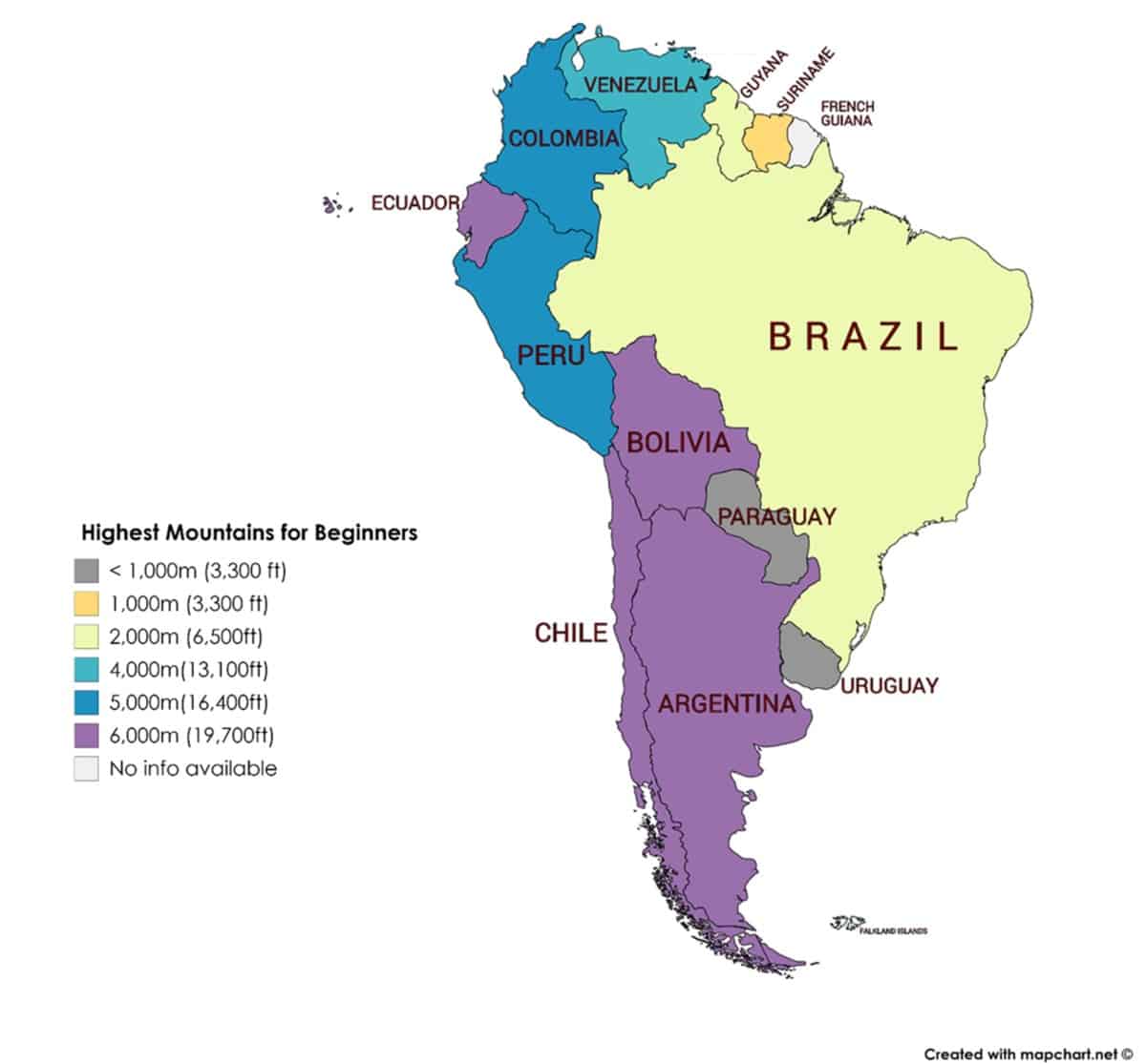
South America may not seem like the typical climbing destination. But did you know that half of the countries in South America actually have mountains that are higher than Europe’s Mount Elbrus?
And some of these peaks are relatively easy glacier climbs. With proper training and acclimatization, even beginners can climb them.
I have put together this resource with 20 of the highest peaks that you can start conquering today!
For more of the highest climbs around the world, check out:
- 56 Highest Mountains To Climb in the US for Beginners
- 56 Highest Mountains To Climb in Europe for Beginners
- 74 Highest Mountains To Climb in Asia for Beginners
- 27 Highest Mountains To Climb in North America for Beginners
- 18 Highest Mountains To Climb in Africa for Beginners
But not all these climbs are easy! Some of the climbs are in high altitudes or have icy conditions. You should consider hiring a guide if you do not have the relevant experience or skills for the climbs.
Before We Start…
Just a few things to note before jumping right into the list. It will be helpful for you to first understand a bit about some of the terminology used in the list. These are also terminology that you may have seen from other sources.
Thousanders
In South America, the elevations of the mountains are typically referred to in meters. They are usually referred to as n-thousanders.
The highest mountain in South America is a six-thousander.
- Six-thousanders: at least 6,000 meters (19,685 feet) but less than 7,000 meters
- Five-thousanders: at least 5,000 meters (16,404 feet) but less than 6,000 meters
- Four-thousanders: at least 4,000 meters (13,123 feet) but less than 5,000 meters (16,404 feet)
- Three-thousanders: at least 3,000 meters (9,842 feet) but less than 4,000 meters
- Two-thousanders: at least 2,000 meters (6,561 feet) but less than 3,000 meters
- One-thousanders: at least 1,000 meters (3,281 feet) but less than 2,000 meters
What Is Summitpost?
I have provided a SummitPost link for each of the listed climbs below.
SummitPost is an online library of climbing information for mountains around the world.
The information is provided by a community of climbers. It can be a useful starting point to learn more about the mountains and climbs. However, do note that not all information is fully kept up to date or complete. It will be good to do additional research before your climbs.
Since it is a community-driven initiative, it will be great if you could highlight any errors or outdated information. You can do so in the comments section of the respective pages.
Rating Systems
There are many rating systems that grades the difficulty of a climb.
There are a few grading systems used in this list:
Yosemite Decimal System (YDS)
- This is the grading system used widely in the US to rate the difficulty of a climb.
- Class 1 and 2 climbs are suitable for beginners.
- Beginners can attempt Class 3 climbs with a guide.
- Read more about YDS here.
Union Internationale des Associations d’Alpinisme (UIAA)
- This is the grading system used in many countries in Europe.
- Beginners can attempt Grade I climbs with a guide.
- Beginners can attempt Grade II climbs after some lessons or training.
- Read more about UIAA here.
International French Adjectival System (IFAS) aka Alpine Rating System
- This is the grading system used in Europe for climbing in alpine conditions.
- F and PD climbs can be suitable for beginners if the routes do not have any snow or ice.
- Beginners can attempt F and PD climbs in snowy or icy terrains with a guide.
- Read more about IFAS here.
Difference Between Elevation And Elevation Gain
You may notice that the list below states both the elevation and elevation gained.
The elevation measures to the height of the summit above sea level.
The elevation gained is the difference in height from the start of the trail to the summit.
The elevation gained might be different between routes. This depends on the trailheads which may be at different points on the mountains.
Climbing Season Vs Best Time To Climb
For each of the climbs listed below, I have included the climbing season as well as the best time to climb.
Beginners should stick to the duration listed under the best time to climb.
Though climbing is still possible for the rest of the year, it is more suitable for experienced climbers.
The conditions are harsher and the climb’s difficulty rating also increases. Non-technical climbs can often turn into technical ones.
List Of The Highest Beginner Mountains To Climb In South America
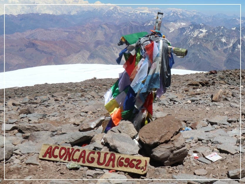
The highest mountain in South America is Aconcagua in Argentina. Standing at 6,960 meters (22,835 feet), it is the second highest peak among the Seven Summits.
Argentina
The highest peak in Argentina is a six-thousander. Argentina has more than 20 six-thousanders.
1. Aconcagua (6,960 meters / 22,835 feet)
- The highest peak in Argentina and South America.
- One of the world’s Seven Summits. It is the second highest among the Seven Summits.
- Although it is a non-technical climb, the high altitude will be a challenge. Beginners should climb with a guide.
- SummitPost page
| Elevation (meters) | 6,960 |
| Elevation (feet) | 22,835 |
| Popular Routes | Normal route from the northwest |
| Rating | F |
| Elevation Gain (meters) | 4,010 |
| Elevation Gain (feet) | 13,156 |
| Distance (kilometers) | 70 |
| Distance (miles) | 43 |
| Route Type | Loop |
| Climbing Season | All year |
| Best Time | Dec to Feb |
| Snow And Ice | All year |
| Climbing Permit Required | Yes |
Ojos Del Salado (6,893 meters / 22,615 feet)
- Located on the border between Argentina and Chile.
- The second highest peak in Argentina and South America. It is also the highest peak in Chile.
- See number 8 for more information.
2. Monte Pissis (6,795 meters / 22,293 feet)
- The third highest peak in Argentina and South America.
- The second highest volcano in the world.
- Although the easiest route is not a technical climb, it is a glacier climb. Beginners should climb with a guide.
- SummitPost page
| Elevation (meters) | 6,795 |
| Elevation (feet) | 22,293 |
| Popular Routes | Start from Pissis BC on the northern side |
| Rating | YDS Class 3 PD |
| Elevation Gain (meters) | 2,195 |
| Elevation Gain (feet) | 7,201 |
| Duration | 5 days* (distance unknown) |
| Route Type | depends on route |
| Climbing Season | All year |
| Best Time | Dec to Mar |
| Snow And Ice | All year |
| Climbing Permit Required | No |
*This is the duration of the actual climb. It excludes acclimatization days.
Cerro Llullaillaco (6,739 meters / 22,110 feet)
- Located on the border of Argentina and Chile.
- The fourth highest peak in Argentina.
- It is more commonly climbed from Chile.
- See number 10 for more informaiton.
3. Cerro Mercedario (6,710 meters / 22,014 feet)
- The fifth highest peak in Argentina.
- Overshadowed by the nearby Aconcagua, it is a much less popular climb. A good option if you like to be away from the crowds.
- SummitPost page
.
| Elevation (meters) | 6,710 |
| Elevation (feet) | 22,014 |
| Popular Routes | Normal route from Laguna Blanca |
| Rating | F |
| Elevation Gain (meters) | 3,560 |
| Elevation Gain (feet) | 11,680 |
| Distance (kilometers) | 38 |
| Distance (miles) | 24 |
| Route Type | Loop |
| Climbing Season | All year |
| Best Time | Dec to Mar |
| Snow And Ice | All year |
| Climbing Permit Required | No |
Bolivia
The highest peak in Bolivia is a six-thousander. Bolivia has more than 10 six-thousanders.
4. Nevado Sajama (6,542 meters / 21,463 feet)
- Located on the border between Bolivia and Chile.
- The highest peak in Bolivia.
- An extinct volcano.
- Although the easiest route is not a technical climb, it is a glacier climb. Beginners should climb with a guide.
- SummitPost page
| Elevation (meters) | 6,542 |
| Elevation (feet) | 21,463 |
| Popular Routes | Southwest ridge from Sajama village |
| Rating | UIAA Grade III PD |
| Elevation Gain (meters) | 2,200 |
| Elevation Gain (feet) | 7,218 |
| Distance (kilometers) | 20 |
| Distance (miles) | 12 |
| Route Type | Loop |
| Climbing Season | All year |
| Best Time | Jul to Sep |
| Snow And Ice | All year |
| Climbing Permit Required | No |
5. Illimani (6,438 meters / 21,122 feet)
- The second highest peak in Bolivia.
- It towers over La Paz, the capital of Bolivia.
- Although the easiest route is not a technical climb, it is a glacier climb. Beginners should climb with a guide.
- SummitPost page
| Elevation (meters) | 6,438 |
| Elevation (feet) | 21,122 |
| Popular Routes | Normal route from Nido de Condores |
| Rating | UIAA Grade II PD |
| Elevation Gain (meters) | 2,700 |
| Elevation Gain (feet) | 8,858 |
| Duration | 4 days* (distance unknown) |
| Route Type | Loop |
| Climbing Season | All year |
| Best Time | Jun to Aug |
| Snow And Ice | All year |
| Climbing Permit Required | No |
*This is the duration of the actual climb. It excludes acclimatization days.
6. Ancohuma (6,427 meters / 21,085 feet)
- The third highest peak in Bolivia.
- Although the easiest route is not a technical climb, it is a glacier climb. Beginners should climb with a guide.
- SummitPost page
| Elevation (meters) | 6,427 |
| Elevation (feet) | 21,085 |
| Popular Routes | Normal route via Laguna Glaciar |
| Rating | PD |
| Elevation Gain (meters) | 2,827 |
| Elevation Gain (feet) | 9,274 |
| Duration | 5 days* (distance unknown) |
| Route Type | Loop |
| Climbing Season | All year |
| Best Time | Jun to Aug |
| Snow And Ice | All year |
| Climbing Permit Required | No |
*This is the duration of the actual climb. It excludes acclimatization days.
Brazil
The highest peak in Brazil is a two-thousander. Brazil has 11 two-thousanders.
The highest peak in Brazil is Pico da Neblina which stands at 2,995 meters (9,826 feet). The climb is technical and not suitable for beginners.
Pico 31 de Março (2,974 meters / 9,757 feet)
- The second highest peak in Brazil.
- It is considered a secondary summit of Pico da Neblina which is about 700 meters (2,300 feet) away.
- It is often climbed together with Pico da Neblina. It is seldom climbed on its own and there is not much information online.
7. Pico da Bandeira (2,892 meters / 9,488 feet)
- The third highest peak in Brazil.
- Views of more than 10 surrounding cities and the Atlantic Ocean.
- SummitPost page
| Elevation (meters) | 2,892 |
| Elevation (feet) | 9,488 |
| Popular Routes | Summit trail |
| Rating | YDS Class 1 |
| Elevation Gain (meters) | 1,000 |
| Elevation Gain (feet) | 3,281 |
| Distance (kilometers) | 18 |
| Distance (miles) | 11 |
| Route Type | Loop |
| Climbing Season | All year |
| Best Time | Jun to Sep |
| Snow And Ice | No |
| Climbing Permit Required | No |
Chile
The highest peak in Chile is a six-thousander. Chile has more than 30 six-thousanders.
8. Ojos Del Salado (6,893 meters / 22,615 feet)
- Located on the border between Argentina and Chile.
- The highest peak in Chile and the second highest peak in South America.
- It is also the highest active volcano in the world.
- SummitPost page
| Elevation (meters) | 6,893 |
| Elevation (feet) | 22,615 |
| Popular Routes | Normal route from Refugio Atacama |
| Rating | PD |
| Elevation Gain (meters) | 1,693 |
| Elevation Gain (feet) | 5,554 |
| Distance (kilometers) | 7 |
| Distance (miles) | 4 |
| Route Type | Loop |
| Climbing Season | All year |
| Best Time | Dec to Mar |
| Snow And Ice | Oct to Jan |
| Climbing Permit Required | Yes |
9. Nevado Tres Cruces (6,748 meters / 22,139 feet)
- Located on the border between Argentina and Chile.
- Also known as Cerro Tres Cruces Sur.
- The second highest peak in Chile.
- Although it is a non-technical climb, the challenges for beginners include the high altitude, remote location, and unmarked trails. Beginners should climb with a guide.
- It is rarely climbed due to its remote location.
- SummitPost page
| Elevation (meters) | 6,748 |
| Elevation (feet) | 22,139 |
| Popular Routes | Normal route |
| Rating | YDS Class 2 |
| Alpine | PD |
| Elevation Gain (meters) | 2,324 |
| Elevation Gain (feet) | 7,625 |
| Duration | 3 days* (distance unknown) |
| Route Type | Loop |
| Climbing Season | All year |
| Best Time | Dec to Mar |
| Snow And Ice | Oct to Jan |
| Climbing Permit Required | Yes |
*This is the duration of the actual climb. It excludes acclimatization days.
10. Cerro Llullaillaco (6,739 meters / 22,110 feet)
- Located on the border of Argentina and Chile.
- The third highest peak in Chile.
- It is the second highest active volcano in the world.
- It is the highest archeological site in the world. There were mummies found in 1999.
- Although the climb is not a difficult one, the mountain is rarely climbed due to its remote location.
- SummitPost page
| Elevation (meters) | 6,739 |
| Elevation (feet) | 22,110 |
| Popular Routes | Northwest route |
| Rating | YDS Class 2 PD |
| Elevation Gain (meters) | 2,039 |
| Elevation Gain (feet) | 6,690 |
| Duration | 3 days* (distance unknown) |
| Route Type | Loop |
| Climbing Season | All year |
| Best Time | Feb to Sep |
| Snow And Ice | All year |
| Climbing Permit Required | Border permit |
*This is the duration of the actual climb. It excludes acclimatization days.
Colombia
The highest peak in Colombia is five-thousander, Pico Cristóbal Colón. It stands at 5,700 meters (18,701 feet).
Colombia has more than 7 five-thousanders.
The 4 highest peaks in Colombia are in the Sierra Nevada de Santa Marta range. The mountains are sacred to the locals and climbing is not allowed.
Here are some of the highest peaks in Colombia suitable for beginners:
11. Ritacuba Blanco (5,330 meters / 17,487 feet)
- The 5th highest peak in Colombia.
- Considered one of the most beautiful mountains in Colombia.
- Although the easiest route is not a technical climb, it is a glacier climb. Beginners should climb with a guide.
- SummitPost page
| Elevation (meters) | 5,330 |
| Elevation (feet) | 17,487 |
| Popular Routes | Glacier route from Cabañas de Kanwara |
| Rating | F |
| Elevation Gain (meters) | 1,500 |
| Elevation Gain (feet) | 4,921 |
| Distance (kilometers) | 16 |
| Distance (miles) | 10 |
| Route Type | Loop |
| Climbing Season | All year |
| Best Time | Dec to Feb |
| Snow And Ice | All year |
| Climbing Permit Required | Yes |
12. Nevado Del Ruiz (5,325 meters / 17,470 feet)
- The 7th highest peak in Colombia.
- One of the shortest climbs in the world for a mountain of this altitude.
- SummitPost page
| Elevation (meters) | 5,325 |
| Elevation (feet) | 17,470 |
| Popular Routes | West slopes from Ruiz Refugio |
| Rating | PD- |
| Elevation Gain (meters) | 531 |
| Elevation Gain (feet) | 1,742 |
| Distance (kilometers) | 5 |
| Distance (miles) | 3 |
| Route Type | Loop |
| Climbing Season | All year |
| Best Time | Dec to Mar |
| Snow And Ice | All year |
| Climbing Permit Required | Yes |
13. Nevado del Tolima (5,274 meters / 17,303 feet)
- The 9th highest peak in Colombia.
- An active volcano with a perfectly symmetrical cone.
- Views of lakes, rainforests, and glaciers.
- SummitPost page
| Elevation (meters) | 5,274 |
| Elevation (feet) | 17,303 |
| Popular Routes | Normal route from El Silencio |
| Rating | PD |
| Elevation Gain (meters) | 2,694 |
| Elevation Gain (feet) | 8,839 |
| Duration | 3 days* (distance unknown) |
| Route Type | Loop |
| Climbing Season | All year |
| Best Time | Dec to Mar, Jul to Aug |
| Snow And Ice | All year |
| Climbing Permit Required | Yes |
*This is the duration of the actual climb. It excludes acclimatization days.
Ecuador
The highest peak in Ecuador is a six-thousander. Ecuador has 1 six-thousander and 9 five-thousanders.
14. Chimborazo (6,263 meters / 20,548 feet)
- The highest peak in Ecuador.
- Though it is not the world’s highest mountain, the summit is the furthest point from the center of the earth.
- Although the easiest route is not a technical climb, it is a glacier climb. A guide is required for all glacier climbs in Ecuador.
- SummitPost page
| Elevation (meters) | 6,263 |
| Elevation (feet) | 20,548 |
| Popular Routes | Normal route from Refugio Carrel |
| Rating | PD |
| Elevation Gain (meters) | 1,463 |
| Elevation Gain (feet) | 4,800 |
| Duration | 2 days* (distance unknown) |
| Route Type | Loop |
| Climbing Season | All year |
| Best Time | Jun to Jul, Dec to Jan |
| Snow And Ice | All year |
| Climbing Permit Required | A guide is required |
*This is the duration of the actual climb. It excludes acclimatization days.
15. Cotopaxi (5,897 meters / 19,347 feet)
- The second highest peak in Ecuador.
- It is the third highest active volcano in the world.
- Although the easiest route is not a technical climb, it is a glacier climb. A guide is required for all glacier climbs in Ecuador.
- SummitPost page
| Elevation (meters) | 5,897 |
| Elevation (feet) | 19,347 |
| Popular Routes | Rompe Corazones |
| Rating | UIAA Grade II PD |
| Elevation Gain (meters) | 1,097 |
| Elevation Gain (feet) | 3,599 |
| Duration | 2 days* (distance unknown) |
| Route Type | Loop |
| Climbing Season | All year |
| Best Time | Jun to Jul, Dec to Jan |
| Snow And Ice | All year |
| Climbing Permit Required | A guide is required |
*This is the duration of the actual climb. It excludes acclimatization days.
16. Cayambe (5,790 meters / 18,996 feet)
- The third highest peak in Ecuador.
- The highest point on earth that intersects with the equator. It is the only place on earth where both the temperature and latitude reach zero degrees.
- Although the easiest route is not a technical climb, it is a glacier climb. A guide is required for all glacier climbs in Ecuador.
- SummitPost page
| Elevation (meters) | 5,790 |
| Elevation (feet) | 18,996 |
| Popular Routes | Normal route from south east side |
| Rating | PD |
| Elevation Gain (meters) | 1,090 |
| Elevation Gain (feet) | 3,576 |
| Duration | 2 days* (distance unknown) |
| Route Type | Loop |
| Climbing Season | All year |
| Best Time | Oct to Jan |
| Snow And Ice | All year |
| Climbing Permit Required | A guide is required |
*This is the duration of the actual climb. It excludes acclimatization days.
Guyana
The highest peak in Guyana is a two-thousander.
Mount Roraima (2,810 meters / 9,219 feet)
- Located on the border of Venezuela, Brazil, and Guyana.
- The highest peak in Guyana.
- The mountain is mostly climbed from Venezuela.
- See number 20 for more information.
Paraguay
There are no high mountains to climb in Paraguay.
The highest peak in Paraguay is Cerro Tres Kandú at 842 meters (2,762 feet). It is also known as Cerro Peró.
Peru
The highest peak in Peru is six-thousander, Huascaran Sur. It stands at 6,746 meters (22,133 feet).
Peru is home to almost 20 six-thousanders.
Many of the highest peaks in Peru are technical glacier climbs. They are not suitable for beginners.
Here are some of the highest peaks in Peru suitable for beginners:
17. Nevado Pisco (5,752 meters / 18,871 feet)
- Often used as an acclimatization climb for the six-thousanders.
- 360 views of the Cordillera Blanca mountain range.
- Although the easiest route is not a technical climb, it is a glacier climb. A guide is required unless you are a member of an alpine club.
- SummitPost page
| Elevation (meters) | 5,752 |
| Elevation (feet) | 18,871 |
| Popular Routes | Normal route from the southwest |
| Rating | PD |
| Elevation Gain (meters) | 850 |
| Elevation Gain (feet) | 2,789 |
| Duration | 3 days* (distance unknown) |
| Route Type | Loop |
| Climbing Season | All year |
| Best Time | Jul to Aug |
| Snow And Ice | All year |
| Climbing Permit Required | A guide is required |
*This is the duration of the actual climb. It excludes acclimatization days.
18. Nevado Vallunaraju (5,686 meters / 18,655 feet)
- One of the most popular climbs in the Cordillera Blanca mountain range.
- Often used as an acclimatization climb for the six-thousanders.
- Although the easiest route is not a technical climb, it is a glacier climb. A guide is required unless you are a member of an alpine club.
- SummitPost page
| Elevation (meters) | 5,686 |
| Elevation (feet) | 18,655 |
| Popular Routes | Normal route from the southwest |
| Rating | PD |
| Elevation Gain (meters) | 1,300 |
| Elevation Gain (feet) | 4,265 |
| Duration | 2 days* (distance unknown) |
| Route Type | Loop |
| Climbing Season | All year |
| Best Time | Jun to Aug |
| Snow And Ice | All year |
| Climbing Permit Required | A guide is required |
*This is the duration of the actual climb. It excludes acclimatization days.
19. Nevado Ishinca (5,530 meters / 18,143 feet)
- One of the most popular climbs in the Cordillera Blanca mountain range.
- Often used as an acclimatization climb for the six-thousanders.
- Although the easiest route is not a technical climb, it is a glacier climb. Beginners should climb with a guide.
- SummitPost page
| Elevation (meters) | 5,530 |
| Elevation (feet) | 18,143 |
| Popular Routes | Normal route from the southwest |
| Rating | F |
| Elevation Gain (meters) | 1,200 |
| Elevation Gain (feet) | 3,937 |
| Duration | 3 days* (distance unknown) |
| Route Type | Loop |
| Climbing Season | All year |
| Best Time | Jul to Aug |
| Snow And Ice | All year |
| Climbing Permit Required | Yes |
*This is the duration of the actual climb. It excludes acclimatization days.
Suriname
The highest peak in Suriname is a one-thousander.
Julianatop (1,280 meters / 4,199 feet)
- The highest peak in Suriname.
- There is very limited information online. You can contact local guides to get more information.
Uruguay
There are no high mountains to climb in Uruguay. Uruguay has the lowest country highpoint in South America.
The highest peak in Uruguay is Cerro Catedral at 513 meters (1,683 feet). It is also known as Cathedral Hill or Cerro Cordillera.
Venezuela
The highest peak in Venezuela is four-thousander, Pico Bolívar. It stands at 4,978 meters (16,332 feet). The climb is technical and not suitable for beginners.
Venezuela has 5 four-thousanders.
Due to climate change, Some of the highest glaciers in Venezuela have disappeared. This includes the third and fourth highest peaks in Venezuela — Pico La Concha and Pico Bonpland.
And because of Venezuela’s political instability, the mountains are not climbed often.
Other than the two peaks listed below, there is very little information about the other mountains in Venezuela.
Pico Espejo (4,880 meters / 16,010 feet)
- Also known as Mirror Peak.
- The fifth highest peak in Venezuela.
- There is actually minimal climbing to be done. You can take the Mérida Cable Car near to the peak. The Mérida Cable Car is the highest cable car in the world.
20. Mount Roraima (2,810 meters / 9,219 feet)
- Located on the border of Venezuela, Brazil, and Guyana.
- Although the easiest route is not a technical climb, there are no proper routes. Beginners should climb with a guide.
- SummitPost page
- Blog article
| Elevation (meters) | 2,810 |
| Elevation (feet) | 9,219 |
| Popular Routes | Paratepui route |
| Rating | YDS Class 3 |
| Elevation Gain (meters) | 1,520 |
| Elevation Gain (feet) | 4,987 |
| Distance (kilometers) | 56 |
| Distance (miles) | 35 |
| Route Type | Loop |
| Climbing Season | All year |
| Best Time | Dec to Mar |
| Snow And Ice | No |
| Climbing Permit Required | Yes |
Can’t get enough? Check these out: