Are you thinking of taking up mountain climbing? Are you looking for some mountains that are suitable for beginners?
Or maybe you would like to introduce your kids to a new sport?
Or you have some friends coming to town who would like to spend some time outdoors?
You’re in luck! I’ve spent days putting this list together of all the beginner mountains in the US across all 50 states.
For more of the highest climbs around the world, check out:
- 56 Highest Mountains To Climb in Europe for Beginners
- 74 Highest Mountains To Climb in Asia for Beginners
- 27 Highest Mountains To Climb in North America for Beginners
- 20 Highest Mountains To Climb in South America for Beginners
- 18 Highest Mountains To Climb in Africa for Beginners
- Before We Start…
- List Of Beginner Mountains To Climb In The US
- Alabama
- Alaska
- Arizona
- Arkansas
- California
- Colorado
- Connecticut
- Delaware
- Florida
- Georgia
- Hawaii
- Idaho
- Illinois
- Indiana
- Iowa
- Kansas
- Kentucky
- Louisiana
- Maine
- Maryland
- Massachusetts
- Michigan
- Minnesota
- Mississippi
- Missouri
- Montana
- Nebraska
- Nevada
- New Hampshire
- New Jersey
- New Mexico
- New York
- North Carolina
- North Dakota
- Ohio
- Oklahoma
- Oregon
- Pennsylvania
- Rhode Island
- South Carolina
- South Dakota
- Tennessee
- Texas
- Utah
- Vermont
- Virginia
- Washington
- West Virginia
- Wisconsin
- Wyoming
This is Part 1 of 6 of the Mountains To Climb In The US Mini-series:
Part 1: Highest Mountains To Climb In The US For Beginners
Part 2: Ultimate Guide To Climbing Mount Elbert
Part 3: Ultimate Guide To Climbing Mount Katahdin
Part 4: Ultimate Guide To Climbing Mount Bierstadt
Part 5: Ultimate Guide To Climbing South Sister
Part 6: Ultimate Guide To Climbing Mount Borah
Before We Start…
Just a few things to note before jumping right into the list. It will be helpful for you to first understand a bit about some of the terminology used in the list. These are also terminology that you may have seen from other sources.
Yosemite Decimal System (YDS)
This is the classification system used widely in the US to rate the difficulty of a climb.
There are 5 classes in the YDS. A non technical climb is one where you do not need any specialized climbing skills or tools. LINK
Class 1: Non technical climb. Walking or hiking on trails. no route finding skills required.
Class 2: Non technical climb. Walking or hiking on trails with occasional use of hands. Route finding skills required.
Class 3: Non technical climb. Frequent use of hands. Safety ropes are used by beginners but are not required.
Class 4: Non technical or technical climb. Safety ropes are typically used.
Class 5: Technical climb. Specialized climbing skills and tools required. There are several sub-classes of Class 5 climbs. These further differentiate the difficulty levels.
In this list, I have only included climbs from Classes 1 to 3. For beginners, you can safely tackle a Class 1 route on your own. For Class 2 and above, it is advisable to follow a guide or an experienced climber. You should only attempt Class 4 and 5 when you have more climbs under your belt. You should also be comfortable with Class 3 climbs.
Note: Class 1 or 2 hikes may not necessarily be easy. There could be steep inclines or high elevation gains. In colder seasons, you may also need crampons and ice axe on some routes.
The class is dependent on the route that you will take to the summit. There could be many routes on one mountain with different class ratings.
The class is also determined by the hardest section in the route or trail. For example, if a particular route is 90% hiking (Class 1) with one Class 5 rock wall to climb, the route will be rated as Class 5.
You can read more about the YDS here.
14ers, 13ers, 12ers And 11ers
Used exclusively in the US, these terms are used to refer to the elevations of mountains. Some climbers like to use these as climbing milestones or to set records, e.g. climbing all the 14ers in Colorado.
A 14er or fourteener is a mountain with an elevation of at least 14,000 feet (4,267 meters). There are 96 14ers in the US, located in only 4 states.
A 13er is a mountain with an elevation between 13,000 (3,962 meters) and 13,999 feet (4,267 meters). There are about 800 to 900 13ers in the US, spread over 9 states.
A 12er is a mountain with an elevation between 12,000 feet (3,657 meters) and 12,999 feet (3,962 meters).
A 11er is a mountain with an elevation between 11,000 feet (3,352 meters) and 11,999 feet (3,657 meters).
Difference Between Elevation And Elevation Gain
You may notice that the list below states both the elevation and elevation gained. The elevation measures to the height of the summit above sea level. The elevation gained is the difference in height from the start of the trail to the summit. The elevation gained might be different between routes. This depends on the trailheads which may be at different points on the mountains.
Difference Between Elevation And Topographic Prominence
As mentioned above, elevation measures to the height of the summit above sea level.
Topographic prominence measures how much taller the peak is compared to its surroundings.
Here’s a helpful image from Wikipedia:
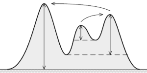
Serious mountaineers are quite particular about the topographic prominence of a mountain. Some may find that reaching a peak with a low topographic prominence is not as significant as reaching one with a high topographic prominence .
The peak with the higher topographic prominence may sometimes be the parent mountain of the lower one. It is thus seen as a more “worthy” climb. The lower peaks are known as the sub-peaks of the parent mountain.
Some lists may rank mountains by elevations. Others may rank them by topographic prominence. These lists can be quite different.
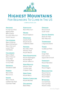
Save to Pinterest and add these mountains to your bucket list!
List Of Beginner Mountains To Climb In The US
The highest mountain in the US is Mount McKinley (Denali) in Alaska, with a height of 20,310 feet (6190 meters). Mount McKinley is the third highest mountain among the Seven Summits (after Mount Everest and Aconcagua).
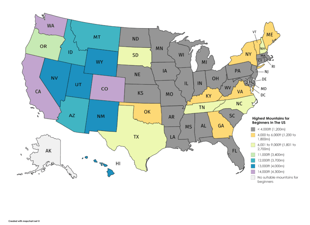
Among the 50 states, only 13 states have peaks above 11,000 feet (3,352 meters). These are the more challenging, multi-day climbs.
Another 15 states have peaks from 4,000 feet (1,219 meters) to 11,000 feet (3,352 meters). Climbing these mountains will take 1 to 2 days.
The mountains in the remaining 22 states are lower than 4,000 feet. These may not be a challenge if you are already a frequent hiker. They usually take less than a day.
Alabama
There are no high mountains to climb in Alabama.
The highest peak in Alabama is Cheaha Mountain at 2,407 feet (734 meters).
Alaska
The state with the highest peak in the US, Mount McKinley (Denali). Mount McKinley is also one of the world’s 7 Summits, coming in third after Mount Everest and Aconcagua.
Alaska is home to 29 14ers and 41 13ers. It has the second most number of 14ers in the US.
Many of the mountains in Alaska have harsh climbing conditions. These include high altitudes, freezing temperatures and icy terrains.
There are some peaks which are suitable for beginners in good physical condition. But they tend to be rather inaccessible and requires a guided tour. These tours can also be quite costly.
Here are some of the tours I found online — Mountain Trip and American Alpine Institute.
Arizona
Arizona is home to 2 12ers and 10 11ers.
Arizona 20-20 Challenge
There is also an old Arizona 20-20 Challenge, listing the 20 highest peaks and 20 deepest canyons. You can find more information here.
Here are some of the more popular mountain climbs in the state:
1. Humphreys Peak
- Tallest peak in Arizona
- Views of Grand Canyon and the desert mountains near Phoenix
- SummitPost page
| Elevation (feet) | 12,637 |
| Elevation (meters) | 3,852 |
| Popular Route | Humphreys Peak trail |
| YDS Class | Class 1 |
| Elevation Gained (feet) | 3,343 |
| Elevation Gained (meters) | 1,019 |
| Distance (miles) | 9.2 |
| Distance (kilometers) | 15 |
| Route Type | Loop |
| Climbing Season | All year |
| Best Time To | Jun — Oct |
| Snow And/Or Ice | Winter |
| Permit Requirement | Only in winter |
2. Agassiz Peak
- The second highest peak in Arizona
- Often mistaken for Humphreys Peak as it is the most visible mountain from town
- Climbing can only
done during winter when the ground is covered in snow. This is to protect the habitat and plants in the area. - Views of Grand Canyon, Humphreys Peak and other tall peaks in the surroundings
- SummitPost page
| Elevation (feet) | 12,356 |
| Elevation (meters) | 3,766 |
| Popular Route | Humphreys Trail |
| YDS Class | Class 2 |
| Elevation Gain (feet) | 3,036 |
| Elevation Gain (meters) | 925 |
| Distance (miles) | 6 |
| Distance (kilometers) | 10 |
| Route Type | Loop |
| Climbing Season | Winter |
| Best Time To Climb | Winter |
| Snow And/Or Ice | Winter |
| Permit Requirement | Kachina Peaks Wilderness Access permit |
3. Mount Baldy
- The second highest mountain outside of Humphreys Peak (and it’s subpeaks).
- The second highest peak in the Arizona 20-20 Challenge.
- Lies within the White Mountain Apache Indian Reservation
- View of the rock formations in the surroundings
- SummitPost page
| Elevation (feet) | 11,420 |
| Elevation (meters) | 3,481 |
| Popular Route | East Baldy Trail #95 |
| YDS Class | Class 1 |
| Elevation Gain (feet) | 2,100 |
| Elevation Gain (meters) | 640 |
| Distance (miles) | 14 |
| Distance (kilometers) | 23 |
| Route Type | Loop |
| Climbing Season | All year |
| Best Time To Climb | All year |
| Snow And/Or Ice | Winter |
| Permit Requirement | No |
4. Escudilla Mountain
- The third highest mountain outside of Humphreys Peak and Mount Baldy (and their sub-peaks).
- The third highest peak in the Arizona 20-20 Challenge.
- Views of New Mexico
- SummitPost page
| Elevation (feet) | 10,912 |
| Elevation (meters) | 3,326 |
| Popular Route | Escudilla National Recreation Trail #308 |
| YDS Class | Class 1 |
| Elevation Gain (feet) | 1,300 |
| Elevation Gain (meters) | 396 |
| Distance (miles) | 6 |
| Distance (kilometers) | 10 |
| Route Type | Loop |
| Climbing Season | May to Oct |
| Best Time To Climb | October |
| Snow And/Or Ice | Winter |
| Permit Requirement | No |
5. Grand Canyon
- Though not technically a mountain climb, the elevation gain from the Colorado River to the rim is higher than any of the mountains in Arizona
- The deepest canyon in the Arizona 20-20 Challenge
- A unique challenge since you are descending first before making your way back up
- National Park Service page
| Elevation (feet) | 6,850 |
| Elevation (meters) | 2,088 |
| Popular Route | Bright Angel Trail |
| YDS Class | Class 1 |
| Elevation Gain (feet) | 4,460 |
| Elevation Gain (meters) | 1,359 |
| Distance (miles) | 16 |
| Distance (kilometers) | 26 |
| Route Type | Loop |
| Climbing Season | May — Oct |
| Best Time To Climb | May — Oct |
| Snow And/Or Ice | Winter |
| Permit Requirement | No |
Arkansas
There are no high mountains to climb in Arkansas.
The highest peak in Arkansas is Mount Magazine (Signal Hill). There are 2 summits on Mount Magazine, Signal Hill and Mossback Ridge. Signal Hill is the highest peak in Arkansas at 2,753 feet (839 meters). Mossback Ridge reaches 2,700 feet (823 meters).
California
California is home to 12 14ers and 149 13ers. It has the third most number of 14ers in the US after Colorado and Alaska.
6. Mount Whitney
- The highest peak in California
- The highest peak in the contiguous US
- Views of Sierra’s highest peaks and low lying desert plains (including Death Valley)
- SummitPost page
- National Park Service page
| Elevation (feet) | 14,505 |
| Elevation (meters) | 4,421 |
| Popular Route | Mount Whitney Trail |
| YDS Class | Class: 1 |
| Elevation Gain (feet) | 6,960 |
| Elevation Gain (meters) | 2,121 |
| Distance (miles) | 22 |
| Distance (kilometers) | 35 |
| Route Type | Loop |
| Climbing Season | All year |
| Best Time To Climb | Jul to Sep |
| Snow And/ Or Ice | Winter to early summer |
| Permit Requirement | Yes |
7. Mount Williamson
- The second highest peak in California
- If you are looking for something more challenging, try out Mount Williamson. It has a greater elevation gain and a tougher class rating than Mount Whitney.
- SummitPost page
| Elevation (feet) | 14,375 |
| Elevation (meters) | 4,381 |
| Popular Route | Shephard’s Pass Trailhead |
| YDS Class | Class 3 |
| Elevation Gain (feet) | 10,500 |
| Elevation Gain (meters) | 3,200 |
| Distance (miles) | 27 |
| Distance (kilometers) | 43 |
| Route Type | Loop |
| Climbing Season | All year |
| Best Time To Climb | Aug to Oct |
| Snow And/ Or Ice | Nov to Jun |
| Permit Requirement | No |
8. Mount Barnard
- The highest 13er in California is just 10 feet shy of becoming a 14er.
- The 13ers are typically not as popular as the 14ers so you might be able to enjoy a quieter and more peaceful climb.
- It used to be frequently climbed in the early 1900s when it was mistakenly counted as a 14er (aww, this kinda breaks my heart)
- SummitPost page
| Elevation (feet) | 13,990 |
| Elevation (meters) | 4,264 |
| Popular Route | Start from George Creek |
| YDS Class | Class 2 |
| Elevation Gain (feet) | 7,700 |
| Elevation Gain (meters) | 2,347 |
| Distance (miles) | 13 |
| Distance (kilometers) | 21 |
| Route Type | Loop |
| Climbing Season | All year |
| Best Time To Climb | May to Oct |
| Snow And/ Or Ice | Winter |
| Permit Requirement | No |
9. Lassen Peak
- A shorter but more (in)famous peak.
- One of only two volcanoes in the contiguous United States to erupt in the 1900s
- An active but dormant volcano
- Smells of rotten-eggs near the summit due to the hydrogen sulphide from the volcano
- Spectacular views of the Devastated Area. You can witness the damages from the 1914-17 eruptions.
- SummitPost page
- National Park Service page
| Elevation (feet) | 0,457 |
| Elevation (meters) | 3,187 |
| Popular Route | Lassen Peak Trail |
| YDS Class | Class 1 |
| Elevation Gain (feet) | 2,000 |
| Elevation Gain (meters) | 610 |
| Distance (miles) | 5 |
| Distance (kilometers) | 8 |
| Route Type | Loop |
| Climbing Season | All year |
| Best Time To Climb | Apr to Sep |
| Snow And/ Or Ice | Winter |
| Permit Requirement | No |
10. Half Dome
- If you want to experience a Class 3 climb with a much lower elevation and elevation gain, Half Dome is a good option.
- The highlight of the trail are the Half Dome Cables. There are 2 metal cables installed near the summit of Half Dome. This allows climbers to climb the last 400 feet without any rock climbing equipment.
- The cables are taken down from October to May but climbing is still allowed (with your own gear and at your own risk).
- Views of Vernal and Nevada Falls, Liberty Cap, and Half Dome. Panoramic views of Yosemite Valley and the High Sierra
- SummitPost page
- National Park Service page
| Elevation (feet) | 8,839 |
| Elevation (meters) | 2,694 |
| Popular Route | Cables Route |
| YDS Class | Class 3 |
| Elevation Gain (feet) | 4,800 |
| Elevation Gain (meters) | 1,463 |
| Distance (miles) | 15 |
| Distance (kilometers) | 24 |
| Route Type | Loop |
| Climbing Season | All year |
| Best Time To Climb | May to Oct |
| Snow And/ Or Ice | Winter |
| Permit Requirement | Yes |
Colorado
Colorado is the climbing heaven of the US. It is home to 53 14ers, 584 13ers, and 676 12ers. It has the most number of 14ers and 13ers in the US. Colorado has almost 4 times the number of 13ers of second place California.
Amazingly, records have been set by 7 people who have climbed all 1,313 4ers, 13ers and 12ers in Colorado!
You can find more information about Colorado’s 14ers here.
You can find more information about Colorado’s 13ers here.
It will be impossible to list all the climbs here. I’ve picked some of the best 14ers, 13ers and 12ers.
11. Mount Elbert
- The highest peak in Colorado
- Second highest peak in the contiguous United States
- Views of Mount Massive (second highest mountain in Colorado) and La Plata Peak
- SummitPost page
- 14ers page
| Elevation (feet) | 14,440 |
| Elevation (meters) | 4,401 |
| Popular Route | North Mount Elbert Trailhead |
| YDS Class | Class 1 |
| Elevation Gain (feet) | 4,700 |
| Elevation Gain (meters) | 1,433 |
| Distance (miles) | 9.5 |
| Distance (kilometers) | 15 |
| Route Type | Loop |
| Climbing Season | All year |
| Best Time To Climb | Jun — Sep |
| Snow And/ Or Ice | Winter |
| Permit Requirement | No |
12. Mount Massive
- The second highest 14er in Colorado.
- Third highest peak in the contiguous United States
- Tougher class rating than Mount Elbert
- SummitPost page
- Forest Service page
| Elevation (feet) | 14,421 |
| Elevation (meters) | 4,396 |
| Popular Route | Mount Massive Trail |
| YDS Class | Class 2 |
| Elevation Gain (feet) | 4,500 |
| Elevation Gain (meters) | 1,372 |
| Distance (miles) | 14.5 |
| Distance (kilometers) | 23 |
| Route Type | Loop |
| Climbing Season | All year |
| Best Time To Climb | Jun to Sep |
| Snow And/ Or Ice | Winter |
| Permit Requirement | Yes |
13. Grays Peak
- One of the easiest 14ers in Colorado (even has bathrooms along the way)
- The 9th highest 14er in Colorado
- Can be done together with Torreys Peak (an additional 0.5 mile)
- There are mountain goats all over the mountain
- SummitPost page
- 14ers page
| Elevation (feet) | 14,270 |
| Elevation (meters) | 4,349 |
| Popular Route | Stephens Gulch Trailhead |
| YDS Class | Class 1 |
| Elevation Gain (feet) | 3,000 |
| Elevation Gain (meters) | 914 |
| Distance (miles) | 8 |
| Distance (kilometers) | 13 |
| Route Type | Loop |
| Climbing Season | All year |
| Best Time To Climb | Apr — Sep |
| Snow And/ Or Ice | Winter |
| Permit Requirement | No |
14. Torreys Peak
- Also one of the easiest 14ers in Colorado
- The 11th highest 14er in Colorado
- Can be done together with Grays Peak (an additional 0.5 mile)
- SummitPost page
- 14ers page
| Elevation (feet) | 14,267 |
| Elevation (meters) | 4,349 |
| Popular Route | Stephens Gulch Trailhead |
| YDS Class | Class 2 |
| Elevation Gain (feet) | 3,000 |
| Elevation Gain (meters) | 914 |
| Distance (miles) | 8 |
| Distance (kilometers) | 13 |
| Route Type | Loop |
| Climbing Season | All year |
| Best Time To Climb | Apr — Sep |
| Snow And/ Or Ice | Winter |
| Permit Requirement | No |
15. Grizzly Peak
- The highest of the 13ers in Colorado
- Views of the Collegiate and Sawatch mountain ranges and other 13ers
- Passes a lake along the way
- SummitPost page
| Elevation (feet) | 13,988 |
| Elevation (meters) | 4,264 |
| Popular Route | McNasser Gulch Trailhead |
| YDS Class | Class 2 |
| Elevation Gain (feet) | 3,200 |
| Elevation Gain (meters) | 975 |
| Distance (miles) | 8 |
| Distance (kilometers) | 13 |
| Route Type | Loop |
| Climbing Season | All year |
| Best Time To Climb | Apr to Aug |
| Snow And/ Or Ice | All year |
| Permit Requirement | No |
Connecticut
16. Bear Mountain
- The highest peak in Connecticut
- Views of Hudson River, the entire Hudson Highlands area and even the skyscrapers of Manhattan
- SummitPost page
| Elevation (feet) | 2,316 |
| Elevation (meters) | 706 |
| Popular Route | Bear Mountain Trail |
| YDS Class | Class 1 |
| Elevation Gain (feet) | 1,676 |
| Elevation Gain (meters) | 511 |
| Distance (miles) | 6 |
| Distance (kilometers) | 10 |
| Route Type | Loop |
| Climbing Season | All year |
| Best Time To Climb | Apr — Oct |
| Snow And/ Or Ice | No |
| Permit Requirement | No |
Delaware
There are no high mountains to climb in Delaware.
The highest point in Delaware is the Ebright Azimuth marker at 448 feet (137 meters).
The highest peak is Iron Hill at 328 feet (100 meters).
Florida
There are no high mountains to climb in Florida.
The highest peak in Florida is Britton Hill at 345 feet (105 meters).
Georgia
17. Brasstown Bald
- The highest peak in Georgia
- 360 views of Georgia and Southern Appalachian Mountains and valleys
- Might catch views of four surrounding states on a clear day
- You can also drive or take a shuttle to the top
- SummitPost page
| Elevation (feet) | 4,784 |
| Elevation (meters) | 1,458 |
| Popular Route | Arkaquah Trail |
| YDS Class | Class 1 |
| Elevation Gain (feet) | 3,600 |
| Elevation Gain (meters) | 1,097 |
| Distance (miles) | 11 |
| Distance (kilometers) | 18 |
| Route Type | Loop |
| Climbing Season | All year |
| Best Time To Climb | Fall |
| Snow And/ Or Ice | No |
| Permit Requirement | No |
Hawaii
Hawaii is home to 2 13ers.
Interestingly enough, there are no 12ers in Hawaii. The peaks above 12,000 feet (3,657 meters) are all sub-peaks of the 13ers.
18. Mauna Kea
- The highest peak in Hawaii.
- Tallest “sea mountain”, rising 33,000 feet (10,058 meters) from the ocean floor.
- You can also drive to the top.
- Views of the ocean all around.
- A short trail near the summit takes you to Lake Waiau. This is the highest lake in the Pacific Rim and is sacred to the Hawaiian people
- University of Hawaii page http://www.ifa.hawaii.edu/info/vis/visiting-mauna-kea/visiting-the-summit.html
- SummitPost page
| Elevation (feet) | 13,796 |
| Elevation (meters) | 4,205 |
| Popular Route | Mauna Kea Trail |
| YDS Class | Class 1 |
| Elevation Gain (feet) | 4,576 |
| Elevation Gain (meters) | 1,395 |
| Distance (miles) | 12 |
| Distance (kilometers) | 19 |
| Route Type | Loop |
| Climbing Season | All year |
| Best Time To Climb | Mar to Dec |
| Snow And/ Or Ice | Winter |
| Permit Requirement | Registration required |
19. Mauna Loa
- The second highest peak in Hawaii.
- The world’s largest mountain.
- One of the most active volcano in the world, last erupted in 1984.
- Views of the ocean all around.
- SummitPost page
| Elevation (feet) | 13,677 |
| Elevation (meters) | 4,169 |
| Popular Route | Mauna Loa Trail |
| YDS Class | Class 1 |
| Elevation Gain (feet) | 7,600 |
| Elevation Gain (meters) | 2,316 |
| Distance (miles) | 43.2 |
| Distance (kilometers) | 70 |
| Route Type | Loop |
| Climbing Season | All year |
| Best Time To Climb | Mar to May, Aug to Oct |
| Snow And/ Or Ice | Winter |
| Permit Requirement | Required for camping |
Idaho
Idaho is home to 9 12ers.
Idaho has its own 12ers challenge. The current record for fastest completion of all 12ers is just over 20 hours.
You can find more information about Idaho’s 12ers and the challenge here.
20. Mount Borah
- The highest peak in Idaho.
- The most popular trail is also known as the Chickenout Ridge. There is a section of the climb at about 11,200 feet where you are exposed to a 2,000 feet drop. It is probably the point where many climbers decide to turn around and head back.
- View of the Chickenout ridge you just survived. Now you just need to pass through it again on the way back.
- SummitPost page
| Elevation (feet) | 12,662 |
| Elevation (meters) | 3,859 |
| Popular Route | Southwest Ridge “Chickenout” |
| YDS Class | Class 3 |
| Elevation Gain (feet) | 5,500 |
| Elevation Gain (meters) | 1,676 |
| Distance (miles) | 7 |
| Distance (kilometers) | 11 |
| Route Type | Loop |
| Climbing Season | All year |
| Best Time To Climb | May to Aug |
| Snow And/ Or Ice | Winter |
| Permit Requirement | No |
21. Leatherman Peak
- The second highest peak in Idaho.
- Views of the Lost Rivers mountain range, including fellow 12er, Mount Church.
- SummitPost page
| Elevation (feet) | 12,228 |
| Elevation (meters) | 3,727 |
| Popular Route | West side of the north ridge |
| YDS Class | Class 3 |
| Elevation Gain (feet) | 4,100 |
| Elevation Gain (meters) | 1,250 |
| Distance (miles) | 8 |
| Distance (kilometers) | 13 |
| Route Type | Loop |
| Climbing Season | All year |
| Best Time To Climb | Jun to Sep |
| Snow And/ Or Ice | Winter |
| Permit Requirement | No |
22. Hyndman Peak
- The lowest 12er in Idaho.
- The only Class 2 climb among the 12ers (the rest are all Class 3).
- Views of Hyndman Peak, and the surrounding Pioneer mountains
- SummitPost page
| Elevation (feet) | 12,009 |
| Elevation (meters) | 3,660 |
| Popular Route | Hyndman Creek trailhead |
| YDS Class | Class 2 |
| Elevation Gain (feet) | 5,009 |
| Elevation Gain (meters) | 1,527 |
| Distance (miles) | 12 |
| Distance (kilometers) | 19 |
| Route Type | Loop |
| Climbing Season | All year |
| Best Time To Climb | Jul to Oct |
| Snow And/ Or Ice | Winter |
| Permit Requirement | No |
Illinois
There are no high mountains to climb in Illinois.
The highest peak in Illinois is Charles Mound at 1,235 feet (376 meters).
Indiana
There are no high mountains to climb in Indiana.
The highest peak in Indiana is Hoosier Hill at 1,257 feet (383 meters).
Iowa
There are no high mountains to climb in Iowa.
The highest point in Iowa is Hawkeye Point at 1,670 feet (509 meters).
Kansas
There are no high mountains to climb in Kansas.
The highest peak in Kansas is Mount Sunflower at 4,039 feet (1,231 meters). The elevation gained from the trailhead to the summit is only about 50 feet (15 meters).
Kentucky
23. Black Mountain
- The highest peak in Kentucky
- You can also drive close to the summit
- Not the most scenic views. There are mining activities in the area and an energy tower at the summit.
- SummitPost page
| Elevation (feet) | 4,139 |
| Elevation (meters) | 1,262 |
| Popular Route | Main trail |
| YDS Class | Class 1 |
| Elevation Gain (feet) | 734 |
| Elevation Gain (meters) | 224 |
| Distance (miles) | 4.6 |
| Distance (kilometers) | 7 |
| Route Type | Loop |
| Climbing Season | All year |
| Best Time To Climb | Dec — Jan |
| Snow And/ Or Ice | Winter |
| Permit Requirement | Signed waiver required |
Louisiana
There are no high mountains to climb in Louisiana.
The highest peak in Louisiana is Mount Driskill at 535 feet (163 meters).
Maine
24. Mount Katahdin
- The highest peak in Maine
- There are many scrambling and technical routes to the summit
- SummitPost page
- State Park page
| Elevation (feet) | 5,269 |
| Elevation (meters) | 1,606 |
| Popular Route | Hunt Trail |
| YDS Class | Class 2 |
| Elevation Gain (feet) | 4,188 |
| Elevation Gain (meters) | 1,277 |
| Distance (miles) | 10.4 |
| Distance (kilometers) | 17 |
| Route Type | Loop |
| Climbing Season | All year |
| Best Time To Climb | Jul |
| Snow And/ Or Ice | Winter |
| Permit Requirement | Daily quota, registration required |
Maryland
There are no high mountains to climb in Maryland.
The highest peak in Maryland is Backbone Mountain at 3,360 feet (1,024 meters).
Massachusetts
There are no high mountains to climb in Massachusetts.
The highest peak in Massachusetts is Mount Greylock at 3,491 feet (1,064 meters).
Michigan
There are no high mountains to climb in Michigan.
The highest peak in Michigan is Mount Arvon at 1,979 feet (603 meters).
Minnesota
There are no high mountains to climb in Minnesota.
The highest peak in Minnesota is Eagle Mountain at 2,301 feet (701 meters).
Mississippi
There are no high mountains to climb in Mississippi.
The highest peak in Mississippi is Woodall Mountain at 807 feet (246 meters).
Missouri
There are no high mountains to climb in Missouri.
The highest peak in Missouri is Taum Sauk Mountain at 1,772 feet (540 meters).
Montana
Montana is home to 27 12ers. These 12ers all sit on a mountain range known as Beartooth range.
The current record for bagging all 12ers in Idaho is a little over 4 days.
You can find more information about Montana’s 12ers here and here.
25. Granite Peak
- One of the toughest climb in this list
- The highest peak in Montana
- Regarded as the second toughest state highpoint climb after Denali in Alaska. This is because of the difficulty of the route, the adverse weather and lack of clearly defined trails.
- Views of other 12ers such as Glacier Peak and Villard Spires
- SummitPost page
| Elevation (feet) | 12,807 |
| Elevation (meters) | 3,904 |
| Popular Route | West Rosebud Trailhead |
| YDS Class | Class 4 |
| Elevation Gain (feet) | 6,300 |
| Elevation Gain (meters) | 1,920 |
| Distance (miles) | 11 |
| Distance (kilometers) | 18 |
| Route Type | Loop |
| Climbing Season | All year |
| Best Time To Climb | Jul to Sep |
| Snow And/ Or Ice | All year |
| Permit Requirement | No |
26. Mount Wood
- The second highest mountain in Montana. But the third highest peak after Granite Peak and its sub-peak Granite West.
- An easier climb than Granite Peak with a Class 2 rating
- View of fellow 12ers Granite Peak and Castle Peak and snowfields all year round
- SummitPost page
| Elevation (feet) | 12,660 |
| Elevation (meters) | 3,859 |
| Popular Route | West Rosebud Standard Route |
| YDS Class | Class 2 |
| Elevation Gain (feet) | 4,800 |
| Elevation Gain (meters) | 1,463 |
| Distance (miles) | 15 |
| Distance (kilometers) | 24 |
| Route Type | Loop |
| Climbing Season | All year |
| Best Time To Climb | Jul to Sep |
| Snow And/ Or Ice | All year |
| Permit Requirement | No |
27. Castle Mountain
- The third highest mountain in Montana. But the fourth highest peak after Granite Peak and its sub-peak Granite West.
- Another Class 2 climb
- View of the mountain’s castle-like appearance at the start of the trail
- View of an amazing reflection in Shadow Lake at the start of the trail
- SummitPost page
| Elevation (feet) | 12,612 |
| Elevation (meters) | 3,844 |
| Popular Routes | South Slopes via Omega Pass |
| YDS Class | Class 2 |
| Elevation Gain (feet) | 2,612 |
| Elevation Gain (meters) | 796 |
| Distance (miles) | 10 |
| Distance (kilometers) | 16 |
| Route Type | Loop |
| Climbing Season | All year |
| Best Time To Climb | Jul to Sep |
| Snow And/ Or Ice | All year |
| Permit Requirement | No |
Nebraska
There are no high mountains to climb in Nebraska.
The highest peak in Nebraska is Panorama Point at 5,429 feet (1,655 meters). The elevation gained from the trailhead to the summit is only about 80 feet (24 meters).
Nevada
Nevada is home to 2 13ers and 4 12ers.
You can find more information about Nevada’s 12ers here.
28. Boundary Peak
- The highest peak in Nevada
- It is a part of a twin Peak with Montgomery Peak in California which is actually 200 feet (61 meters) taller.
- View of the Mono Lake basin, Sierra Nevada Mountains and White Mountains Wilderness
- SummitPost page
- Forest Service page
| Elevation (feet) | 13,147 |
| Elevation (meters) | 4,007 |
| Popular Route | Trail Canyon |
| YDS Class | Class 2 |
| Elevation Gain (feet) | 3,953 |
| Elevation Gain (meters) | 1,205 |
| Distance (miles) | 8.5 |
| Distance (kilometers) | 14 |
| Route Type | Loop |
| Climbing Season | All year |
| Best Time To Climb | Jun to Oct |
| Snow And/ Or Ice | Winter |
| Permit Requirement | Required for camping |
29. Wheeler Peak
- The second highest peak in Nevada.
- Not to be confused with the highest peak in New Mexico which goes by the same name (see number 34)
- Views of the Great Basin National Park
- SummitPost page
| Elevation (feet) | 13,063 |
| Elevation (meters) | 3,982 |
| Popular Route | Summit Trailhead |
| YDS Class | Class 1 |
| Elevation Gain (feet) | 2,900 |
| Elevation Gain (meters) | 884 |
| Distance (miles) | 8 |
| Distance (kilometers) | 13 |
| Route Type | Loop |
| Climbing Season | All year |
| Best Time To Climb | Jun to Aug |
| Snow And/ Or Ice | Winter |
| Permit Requirement | Required for camping |
30. Mount Moriah
- The lowest 12er in Neveda.
- The only 12er not in close proximity to Wheeler Peak (in fact, Wheeler Peak is the parent of all 4 12ers).
- SummitPost page
| Elevation (feet) | 12,067 |
| Elevation (meters) | 3,678 |
| Popular Route | Hendry’s Creek route |
| Class | Class 2 |
| Elevation Gain (feet) | 6,000 |
| Elevation Gain (meters) | 1,829 |
| Distance (miles) | 13 |
| Distance (kilometers) | 21 |
| Route Type | Loop |
| Climbing Season | All year |
| Best Time To Climb | Jun to Aug |
| Snow And/ Or Ice | Winter |
| Permit Requirement | No |
New Hampshire
31. Mount Washington
- The highest peak in New Hampshire
- There are many non technical and technical routes to the summit
- SummitPost page
- Forest Service page
| Elevation (feet) | 6,288 |
| Elevation (meters) | 1,917 |
| Popular Route | Tuckerman Ravine Trail |
| YDS Class | Class 2 |
| Elevation Gain (feet) | 4,238 |
| Elevation Gain (meters) | 1,292 |
| Distance (miles) | 4.2 |
| Distance (kilometers) | 7 |
| Route Type | Loop |
| Climbing Season | All year |
| Best Time To Climb | Jul to Sep |
| Snow And/ Or Ice | Winter |
| Permit Requirement | Yes |
32. Mount Adams
- The second highest peak in New Hampshire
- If you enjoy a challenge, there are also several YDS Class 2 and 3 routes
- Views in all directions
- SummitPost page
- Forest Service page
| Elevation (feet) | 5,774 |
| Elevation (meters) | 1,760 |
| Popular Route | Valley Way trail |
| YDS Class | Class 1 |
| Elevation Gain (feet) | 4,500 |
| Elevation Gain (meters) | 1,372 |
| Distance (miles) | 9 |
| Distance (kilometers) | 14 |
| Route Type | Loop |
| Climbing Season | All year |
| Best Time To Climb | May to Oct |
| Snow And/ Or Ice | Winter |
| Permit Requirement | No |
33. Mount Jefferson
- Not to be confused with the Mount Jefferson in Oregon
- The third highest peak in New Hampshire
- If you enjoy a challenge, there are also several YDS Class 2 and 3 routes
- Views in all directions
- SummitPost page
| Elevation (feet) | 5,712 |
| Elevation (meters) | 1,741 |
| Popular Route | Caps Ridge Trail |
| YDS Class | Class 2 |
| Elevation Gain (feet) | 3,700 |
| Elevation Gain (meters) | 1,128 |
| Distance (miles) | 5 |
| Distance (kilometers) | 8 |
| Route Type | Loop |
| Climbing Season | All year |
| Best Time To Climb | May to Oct |
| Snow And/ Or Ice | Winter |
| Permit Requirement | No |
New Jersey
There are no high mountains to climb in New Jersey.
The highest peak in New Jersey is High Point (literally!) at 1,803 feet (550 meters).
New Mexico
New Mexico is home to 3 13ers and 33 12ers.
.
You can find more information about New Mexico’s 12ers here.
34. Wheeler Peak
- The highest peak in New Mexico
- Not to be confused with the second highest peak in Nevada which goes by the same name (see number 29)
- You can climb it together with Mount Walter
- There are bighorn sheep on the mountains.
- SummitPost page
| Elevation (feet) | 13,161 |
| Elevation (meters) | 4,011 |
| Popular Route | Wheeler Peak Trail |
| YDS Class | Class 1 |
| Elevation Gain (feet) | 3,686 |
| Elevation Gain (meters) | 1,123 |
| Distance (miles) | 16 |
| Distance (kilometers) | 26 |
| Route Type | Loop |
| Climbing Season | All year |
| Best Time To Climb | May to Nov |
| Snow And/ Or Ice | All year |
| Permit Requirement | No |
35. Truchas Peak
- The second highest mountain in New Mexico. But the fourth highest peak after Wheeler Peak and its sub-peaks Mount Walter and Old Mike Peak.
- The Truchas Peak also has 2 other lower peaks — a Middle Truchas Peak and North Truchas Peak. They are both above 13,000 feet.
- Due to the remote location and lack of accessibility, this mountain is rarely climbed. Watch out for crimes near the trailheads
- SummitPost page
| Elevation (feet) | 13,102 |
| Elevation (meters) | 3,993 |
| Popular Route | Western Trailhead |
| YDS Class | Class 3 |
| Elevation Gain (feet) | 6,800 |
| Elevation Gain (meters) | 2,073 |
| Distance (miles) | 12 |
| Distance (kilometers) | 19 |
| Route Type | Loop |
| Climbing Season | All year |
| Best Time To Climb | Jun to Sep |
| Snow And/ Or Ice | Winter |
| Permit Requirement | No |
36. Simpson Peak
- The highest 12er in New Mexico
- Not a very popular climb as the peak only has 170 feet of topographic prominence and not seen as a “real” peak
- You can climb it together with Wheeler Peak but this involves crossing a Class 4 ridge. This is not suitable for beginners.
- SummitPost page
- AllTrails page
| Elevation (feet) | 12,973 |
| Elevation (meters) | 3,954 |
| Popular Route | Williams Lake Trail |
| YDS Class | Class 2 |
| Elevation Gain (feet) | 2,979 |
| Elevation Gain (meters) | 908 |
| Distance (miles) | 7.9 |
| Distance (kilometers) | 13 |
| Route Type | Loop |
| Climbing Season | All year |
| Best Time To Climb | Jun to Oct |
| Snow And/ Or Ice | Winter |
| Permit Requirement | No |
New York
37. Mount Marcy
- The highest peak in New York
- One of the most visited remote peaks in the US
- Views of over 40 of the surroundings peaks in the region
- SummitPost page
| Elevation (feet) | 5,343 |
| Elevation (meters) | 1,629 |
| Popular Route | Van Hoevenberg Trail |
| YDS Class | Class 1 |
| Elevation Gain (feet) | 3,740 |
| Elevation Gain (meters) | 1,140 |
| Distance (miles) | 15 |
| Distance (kilometers) | 24 |
| Route Type | Loop |
| Climbing Season | All year |
| Best Time To Climb | Jun to Sep |
| Snow And/ Or Ice | Oct to May |
| Permit Requirement | No |
North Carolina
38. Mount Mitchell
- The highest peak in North Carolina
- Views of wild flowers in summer
- You can also drive up to about 100 feet (30 meters) below the summit and walk up a short path to the top.
- SummitPost page
- State Park page
| Elevation (feet) | 6,684 |
| Elevation (meters) | 2,037 |
| Popular Route | Mount Mitchell Trail |
| YDS Class | Class 1 |
| Elevation Gain (feet) | 4,004 |
| Elevation Gain (meters) | 1,220 |
| Distance (miles) | 12 |
| Distance (kilometers) | 19 |
| Route Type | Loop |
| Climbing Season | All year |
| Best Time To Climb | May to Oct |
| Snow And/ Or Ice | Winter |
| Permit Requirement | Camping permit |
North Dakota
There are no high mountains to climb in North Dakota.
The highest peak in North Dakota is White Butte at 3,506 feet (1,069 meters).
Ohio
There are no high mountains to climb in Ohio.
The highest peak in Ohio is Campbell Hill at 1,550 feet (472 meters).
Oklahoma
39. Black Mesa
- The highest peak in Oklahoma
- Views of the mesas
- SummitPost page
| Elevation (feet) | 4,973 |
| Elevation (meters) | 1,516 |
| Popular Route | Start from the northeast |
| YDS Class | Class 1 |
| Elevation Gain (feet) | 734 |
| Elevation Gain (meters) | 224 |
| Distance (miles) | 8.5 |
| Distance (kilometers) | 14 |
| Route Type | Loop |
| Climbing Season | All year |
| Best Time To Climb | All year |
| Snow And/ Or Ice | No |
| Permit Requirement | No |
Oregon
Oregon only has 1 11er.
40. Mount Hood
- The highest peak in Oregon.
- One of the most climbed glacier peak in North America after Japan’s Mount Fuji.
- An active but dormant volcano, it last erupted in 1907.
- SummitPost page
| Elevation (feet) | 11,239 |
| Elevation (meters) | 3,426 |
| Popular Route | South Side route |
| YDS Class | Class 2 |
| Elevation Gain (feet) | 5,300 |
| Elevation Gain (meters) | 1,615 |
| Distance (miles) | 8 |
| Distance (kilometers) | 13 |
| Route Type | Loop |
| Climbing Season | All year |
| Best Time To Climb | May to Jul |
| Snow And/ Or Ice | Winter |
| Permit Requirement | Wilderness permit required |
Mount Jefferson
- Not to be confused with the Mount Jefferson in New Hampshire (see number 33)
- The second highest peak in Oregon
- The easiest route on Mount Jefferson is YDS Class 4 and not suitable for beginners.
41. South Sister
- The third highest peak in Oregon
- The highest of the Three Sisters (Middle Sister and North Sister)
- Views of the other 2 Sisters and surrounding peaks and lakes
- SummitPost page
| Elevation (feet) | 11,358 |
| Elevation (meters) | 3,462 |
| Popular Route | Start from south side |
| YDS Class | Class 3 |
| Elevation Gain (feet) | 5,000 |
| Elevation Gain (meters) | 1,524 |
| Distance (miles) | 12.4 |
| Distance (kilometers) | 20 |
| Route Type | Loop |
| Climbing Season | All year |
| Best Time To Climb | Jun to Sep |
| Snow And/ Or Ice | Winter |
| Permit Requirement | Northwest Forest Pass permit |
Pennsylvania
There are no high mountains to climb in Pennsylvania.
The highest peak in Pennsylvania is Mount Davis at 3,213 feet (979 meters).
Rhode Island
There are no high mountains to climb in Rhode Island.
The highest peak in Rhode Island is Jerimoth Hill at 812 feet (247 meters).
South Carolina
There are no high mountains to climb in South Carolina.
The highest peak in South Carolina is Sassafras Mountain at 3,560 feet (1,085 meters).
South Dakota
42. Black Elk Peak
- Formerly known as Harney Peak
- The highest peak in South Dakota
- Views of 4 states — South Dakota, Wyoming, Montana and Nebraska.
- SummitPost page
- Forest Service page
| Elevation (feet) | 7,242 |
| Elevation (meters) | 2,207 |
| Popular Route | Trail Number 9 |
| YDS Class | Class 1 |
| Elevation Gain (feet) | 1,100 |
| Elevation Gain (meters) | 335 |
| Distance (miles) | 7.6 |
| Distance (kilometers) | 12 |
| Route Type | Loop |
| Climbing Season | All year |
| Best Time To Climb | Apr to Oct |
| Snow And/ Or Ice | Winter |
| Permit Requirement | Compulsory registration at the trailhead (free) |
Odakota Mountain
- The second highest peak in South Dakota
- BUT the elevation gained is only 80 feet
- Views are limited at the summit
43. Bear Mountain
- The third highest peak in South Dakota
- You can also drive to the top
- Located in the center of the Black Hills
- Views of the surrounding peaks, better views than Odakota Mountain
- There is an active fire tower on the summit (one of the few remaining ones)
- SummitPost page
| Elevation (feet) | 7,166 |
| Elevation (meters) | 2,184 |
| Popular Route | Start from the northeast |
| YDS Class | Class 1 |
| Elevation Gain (feet) | 1,000 |
| Elevation Gain (meters) | 305 |
| Distance (miles) | 4.4 |
| Distance (kilometers) | 7 |
| Route Type | Loop |
| Climbing Season | All year |
| Best Time To Climb | Apr to Jun, Sep to Oct |
| Snow And/ Or Ice | No |
| Permit Requirement | No |
Tennessee
44. Clingmans Dome
- The highest peak in Tennessee.
- Located in the center of the Great Smoky Mountains National Park, you get great 360 views of the Smokies.
- Has a unique lookout tower that looks like a flying saucer.
- You can also drive to the summit.
- SummitPost page
| Elevation (feet) | 6,643 |
| Elevation (meters) | 2,025 |
| Popular Route | Noland Divide Trail |
| YDS Class | Class 1 |
| Elevation Gain (feet) | 1,800 |
| Elevation Gain (meters) | 549 |
| Distance (miles) | 14.5 |
| Distance (kilometers) | 23 |
| Route Type | Loop |
| Climbing Season | All year |
| Best Time To Climb | May to Oct |
| Snow And/ Or Ice | Winter |
| Permit Requirement | Camping permit required |
Texas
45. Guadalupe Peak
- The highest peak in Texas.
- Views of Texas deserts and Guadalupe Mountains
- SummitPost page
- National Park Service page
| Elevation (feet) | 8,750 |
| Elevation (meters) | 2,667 |
| Popular Route | Guadalupe Peak Trail |
| YDS Class | Class 1 |
| Elevation Gain (feet) | 2,906 |
| Elevation Gain (meters) | 886 |
| Distance (miles) | 8.5 |
| Distance (kilometers) | 14 |
| Route Type | Loop |
| Climbing Season | All year |
| Best Time To Climb | Sep to Oct |
| Snow And/ Or Ice | Winter |
| Permit Requirement | Camping permit required |
Utah
Utah is home to 21 13ers and more than 70 12ers.
You can find more information about Utah’s 13ers here.
You can find more information about Utah’s 12ers here.
46. Kings Peak
- The highest peak in Utah.
- One of the easiest 13ers to climb in Utah.
- You can climb it together with the second highest peak in Utah, South Kings Peak (additional 1.6 miles).
- Views of the Uinta mountain range.
- Kings Peak SummitPost page
- South Kings Peak SummitPost page
| Elevation (feet) | 13,528 |
| Elevation (meters) | 4,123 |
| Popular Route | Henry’s Fork Trailhead |
| YDS Class | Class 2 |
| Elevation Gain (feet) | 5,252 |
| Elevation Gain (meters) | 1,601 |
| Distance (miles) | 15 |
| Distance (kilometers) | 24 |
| Route Type | Loop |
| Climbing Season | All year |
| Best Time To Climb | Jun to Sep |
| Snow And/ Or Ice | Winter |
| Permit Requirement | No |
47. East Lovenia
- The lowest 13er in Utah but the most challenging to climb.
- You can climb it together with Mount Lovenia, the tenth highest 13er in Utah.
- Views of the High Uintas Wilderness area.
- East Lovenia SummitPost page
- Mount Lovenia SummitPost page
| Elevation (feet) | 13,032 |
| Elevation (meters) | 3,972 |
| Popular Route | East Fork Blacks Fork Trail |
| YDS Class | Class 3 |
| Elevation Gain (feet) | 5,050 |
| Elevation Gain (meters) | 1,539 |
| Distance (miles) | 24 |
| Distance (kilometers) | 39 |
| Route Type | Loop |
| Climbing Season | All year |
| Best Time To Climb | Jun to Sep |
| Snow And/ Or Ice | Winter |
| Permit Requirement | Camping permit required |
48. Squaw Benchmark
- The highest 12er in Utah is just 10 feet shy of becoming a 13er.
- Not to be confused with Squaw Peak, another 12er in the area.
- Views of the entire Uinta mountain range and, the reflection of Red Castle Spire in the Red Castle Lake.
- SummitPost page
| Elevation (feet) | 12,990 |
| Elevation (meters) | 3,959 |
| Popular Route | Squaw Benchmark Ridge Loop |
| YDS Class | Class 2 |
| Elevation Gain (feet) | 4,700 |
| Elevation Gain (meters) | 1,433 |
| Distance (miles) | 21 |
| Distance (kilometers) | 34 |
| Route Type | Loop |
| Climbing Season | All year |
| Best Time To Climb | Jun to Oct |
| Snow And/ Or Ice | Winter |
| Permit Requirement | Camping permit required |
Vermont
49. Mount Mansfield
- The highest peak in Vermont
- SummitPost page
| Elevation (feet) | 4,395 |
| Elevation (meters) | 1,340 |
| Popular Route | Sunset Ridge Trail |
| YDS Class | Class 1 |
| Elevation Gain (feet) | 2,600 |
| Elevation Gain (meters) | 792 |
| Distance (miles) | 6.6 |
| Distance (kilometers) | 11 |
| Route Type | Loop |
| Climbing Season | May to Oct |
| Best Time To Climb | May to Oct |
| Snow And/ Or Ice | Winter |
| Permit Requirement | No |
Virginia
50. Mount Rogers
- The highest peak in Virginia
- SummitPost page
| Elevation (feet) | 5,729 |
| Elevation (meters) | 1,746 |
| Popular Route | Via Massie Gap |
| YDS Class | Class 1 |
| Elevation Gain (feet) | 1,079 |
| Elevation Gain (meters) | 329 |
| Distance (miles) | 8 |
| Distance (kilometers) | 13 |
| Route Type | Loop |
| Climbing Season | All year |
| Best Time To Climb | Jun to Sep |
| Snow And/ Or Ice | Winter |
| Permit Requirement | No |
Washington
Washington is home to 2 14ers but both 4 peaks belong to the same mountain, Mount Rainier.
It has the least number of 14ers in the US and has no 13ers.
51. Mount Rainier
- The highest peak in Washington.
- Fifth highest peak in the contiguous United States
- An active volcano and the most glaciated peak in the contiguous US.
- SummitPost page
- National Park Service page
| Elevation (feet) | 14,409 |
| Elevation (meters) | 4,392 |
| Popular Route | Disappointment Cleaver and Emmons Glacier |
| YDS Class | Class 3 |
| Elevation Gain (feet) | 9,000 |
| Elevation Gain (meters) | 2,743 |
| Distance (miles) | 14 |
| Distance (kilometers) | 23 |
| Route Type | Loop |
| Climbing Season | All year |
| Best Time To Climb | May to Aug |
| Snow And/ Or Ice | Winter |
| Permit Requirement | Yes |
52. Mount Adams
- The second highest mountain in Washington. But the third highest peak after Mount Rainier and its sub-peak Liberty Cap.
- The only 12er in Washington.
- It has a subpeak, Little Tahoma Peak, the only 11er in Washington.
- There is snow and ice on the mountain all year round.
- SummitPost page
- Forest Service page
| Elevation (feet) | 12,276 |
| Elevation (meters) | 3,742 |
| Popular Route | South Spur |
| YDS Class | Class 1 |
| Elevation Gain (feet) | 6,700 |
| Elevation Gain (meters) | 2,042 |
| Distance (miles) | 14 |
| Distance (kilometers) | 23 |
| Route Type | Loop |
| Climbing Season | All year |
| Best Time To Climb | May to Oct |
| Snow And/ Or Ice | All year |
| Permit Requirement | Camping permit required |
53. Mount Baker
- The third highest mountain in Washington. But the fifth highest peak after Mount Rainier and Mount Adams and their sub-peaks.
- A volcano which is also the iciest mountain in the Cascade Range.
- There is snow and ice on the mountain all year round.
- SummitPost page
| Elevation (feet) | 10,778 |
| Elevation (meters) | 3,285 |
| Popular Route | Coleman/Deming route |
| YDS Class | Class 2 |
| Elevation Gain (feet) | 7,000 |
| Elevation Gain (meters) | 2,134 |
| Distance (miles) | 11 |
| Distance (kilometers) | 18 |
| Route Type | Loop |
| Climbing Season | All year |
| Best Time To Climb | May to Oct |
| Snow And/ Or Ice | All year |
| Permit Requirement | Optional registration |
West Virginia
There are no high mountains to climb in West Virginia.
The highest peak in West Virginia is Spruce Knob at 4,863 feet (1,482 meters). The summit is only a 0.2 mile (meters) hike from the parking lot.
Wisconsin
There are no high mountains to climb in Wisconsin.
The highest peak in Wisconsin is Timms Hill at 1,952 feet (595 meters).
Wyoming
Wyoming is home to 35 13ers and over a hundred 12ers.
You can find more information about Wyoming’s 13ers here.
54. Gannett Peak
- The highest peak in Wyoming.
- An easier climb than the second highest but more famous Grand Teton. Grand Teton is a technical climb and is not suitable for beginners.
- Views of the Wind River Range
- SummitPost page
| Elevation (feet) | 13,804 |
| Elevation (meters) | 4,207 |
| Popular Route | Pole Creek Trail |
| YDS Class | Class 3 |
| Elevation Gain (feet) | 9,050 |
| Elevation Gain (meters) | 2,758 |
| Distance (miles) | 40 |
| Distance (kilometers) | 64 |
| Route Type | Loop |
| Climbing Season | Jun to Sep |
| Best Time To Climb | Jul to Aug |
| Snow And/ Or Ice | All year |
| Permit Requirement | No |
55. Fremont Peak
- The third highest peak in Wyoming.
- An easier climb than Gannett Peak.
- SummitPost page
| Elevation (feet) | 13,745 |
| Elevation (meters) | 4,189 |
| Popular Route | Elkhart Park Trailhead |
| YDS Class | Class 3 |
| Elevation Gain (feet) | 2,000 |
| Elevation Gain (meters) | 610 |
| Distance (miles) | 30 |
| Distance (kilometers) | 48 |
| Route Type | Loop |
| Climbing Season | All year |
| Best Time To Climb | Jul to Sep |
| Snow And/ Or Ice | All year |
| Permit Requirement | No |
56. Mount Crosby
- The highest non technical 12er in Wyoming
- Views of Absaroka summits and Wyoming’s Washakie Wilderness. The latter is possibly the wildest country in contiguous US.
- SummitPost page
| Elevation (feet) | 12,449 |
| Elevation (meters) | 3,794 |
| Popular Route | Brown Basin Trail |
| YDS Class | Class 2 |
| Elevation Gain (feet) | 3,300 |
| Elevation Gain (meters) | 1,006 |
| Distance (miles) | 8 |
| Distance (kilometers) | 13 |
| Route Type | Loop |
| Climbing Season | All year |
| Best Time to Climb | Jun to Aug |
| Snow And/ Or Ice | Winter |
| Permit Requirement | No |
This is Part 1 of 6 of the Mountains To Climb Around The World Mini-series:
Part 1: 56 Highest Mountains To Climb in the US for Beginners
Part 2: 56 Highest Mountains To Climb in Europe for Beginners
Part 3: 74 Highest Mountains To Climb in Asia for Beginners
Part 4: 27 Highest Mountains To Climb in North America for Beginners
Part 5: 20 Highest Mountains To Climb in South America for Beginners
Part 6: 18 Highest Mountains To Climb in Africa for Beginners
Save to Pinterest and add these mountains to your bucket list!