Thinking of climbing Mount Borah? Mount Borah is the highest mountain in Idaho, USA. The mountain is famous for its “Chicken Out Ridge”. This is a narrow ridge that climbers have to cross on the route up to the summit. Climbers face a 2,000 feet (610 meters) drop on either side of this ridge!
It may not seem like much to an experienced climber or mountaineer. But for the average hiker, this is the point where they “chicken out” and turn back. Can you overcome your nerves to conquer this summit?
- Where Is Mount Borah?
- How Are The Views On Mount Borah?
- When Is The Best Time To Climb Mount Borah?
- What Are The Temperatures On Mount Borah?
- How Long Does It Take To Climb Mount Borah?
- How Many Trails Are There?
- How Do You Choose Which Trail To Take?
- What To Expect On The Southwest Ridge “Chicken Out”
- What Time Should You Start Climbing (Itineraries)
- Do You Need A Permit? Are There Any Fees?
- What To Wear
- Packing List And What To Bring
- How To Get To The Southwest Ridge “Chicken Out” Trailhead?
- Locations Of Parking Lots
- Camping And Accommodation
- Climbing Mount Borah In Winter: A Recap And Important Things to Note
- What Are The Dangers Of Climbing Mount Borah?
- Other Important Information
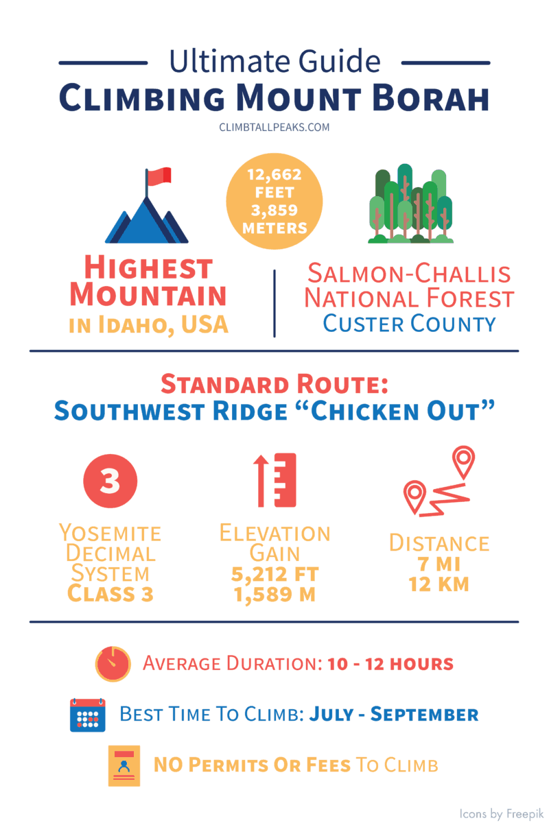
Here is some quick information about the climb at a glance:
| Elevation (feet) | 12,662 |
| Elevation (meters) | 3,859 |
| Popular Route | Southwest Ridge “Chicken Out” |
| YDS Class | Class 3 |
| Elevation Gain (feet) | 5,500 |
| Elevation Gain (meters) | 1,676 |
| Distance (miles) | 7 |
| Distance (kilometers) | 11 |
| Route Type | Loop |
| Climbing Season | All year |
| Best Time To Climb | May to Aug |
| Snow And/ Or Ice | Winter |
| Permit Requirement | No |
This is Part 6 of 6 of the Mountains To Climb In The US Mini-series:
Part 1: Highest Mountains To Climb In The US For Beginners
Part 2: Ultimate Guide To Climbing Mount Elbert
Part 3: Ultimate Guide To Climbing Mount Katahdin
Part 4: Ultimate Guide To Climbing Mount Bierstadt
Part 5: Ultimate Guide To Climbing South Sister
Part 6: Ultimate Guide To Climbing Mount Borah
Where Is Mount Borah?
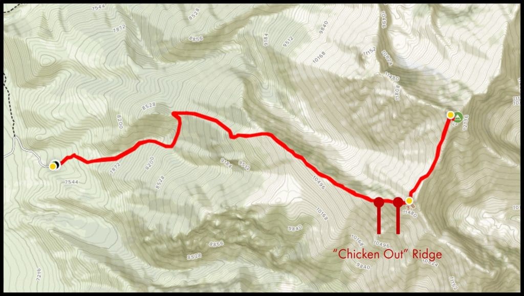
Mount Borah is located in Salmon-Challis National Forest.
Here’s a map giving you a quick orientation of the area around Mount Borah:
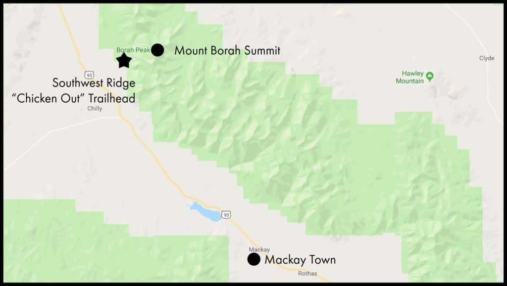
The standard route for climbing Mount Borah is the Southwest Ridge “Chicken Out”.
The nearest town to Mount Borah is Mackay. It is about 21 miles (34 km) away and lies to the southeast of Mount Borah.
The ranger’s office is in Mackay. You can visit them for more information before your climb.
Lost River Ranger District
Address: 716 Custer St, Mackay, ID 83251, USA
Phone: 208 588 3400
Operating hours: Mon to Fri, 8 am to 4.30 pm
How Are The Views On Mount Borah?
This is one of the best reason for climbing Mount Borah. Being the highest point in Idaho, the views are unbeatable. Mount Borah is surrounded by mountains and you get a panoramic view of the 6 major mountain ranges in Idaho.
From the summit, you can also see the famed Chicken Out Ridge.
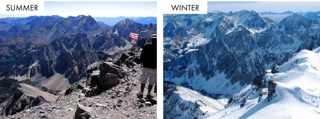
When Is The Best Time To Climb Mount Borah?
The climbing season generally runs from July to September. This is also the peak season where you will see more climbers.
Outside of the season, you will find more snow and ice in the mountains. Early season and winter climbs are also possible. But these are challenging technical climbs. Roads may also be closed during this period. You can check the Forest Service website or contact the ranger’s office for the latest updates.
Climbing Mount Borah in winter is more suited for experienced climbers. The standard route is already a challenging climb in summer. Expect tougher conditions in winter.
There are also many technical winter routes on Mount Borah. There is more information on winter climbs in the section below.
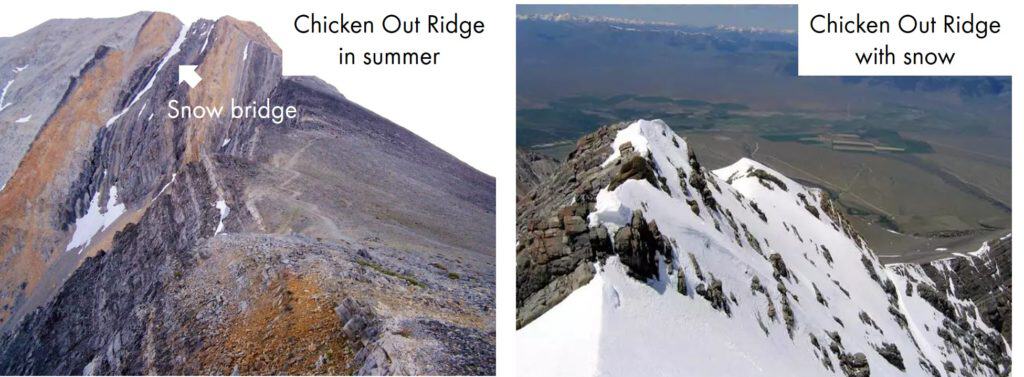
Here’s a comparison of the conditions in summer and winter:
Save to Pinterest and add this to your bucket list!

What Are The Temperatures On Mount Borah?
Climbing Mount Borah is going to be pretty chilly all year round.
These are the average monthly temperatures on Mount Borah. Strong winds on the trails might make it feel a lot colder.
| Low/ High (Fahrenheit) | Low/ High (Celsius) | |
| January | -16 / 8 | -27 / -13 |
| February | -13 / 13 | -25 /-11 |
| March | -3 / 21 | -19 / -6 |
| April | 4 / 31 | -15 / 0 |
| May | 11 / 41 | -12 / 5 |
| June | 18 / 50 | -8 / 10 |
| July | 24 / 60 | -5 / 16 |
| August | 21 / 58 | -6 / 15 |
| September | 13 / 49 | -10 / 9 |
| October | 5 / 36 | -15 / 2 |
| November | -5 / 18 | -21 / -8 |
| December | -15 / 8 | -26 / -13 |
Do note that the temperature drops as you go higher up the mountain.
The elevation gain from the trailheads to the summit is more than 5,000 feet (1,520 meters). You can expect a temperature drop of about 25 F (14 C) from the trailhead to the summit.
The conditions and temperatures vary year to year. Make sure you check the latest forecast before your climb.
How Long Does It Take To Climb Mount Borah?
The average time for a round trip on the Southwest Ridge “Chicken Out” is about 10 to 12 hours. In good conditions, fast climbers can even complete it in 5 hours.
This is for summer climbs. Expect longer climbs in the winter.
Here are some factors to consider when estimating the time you need:
- Health and fitness levels: If you are an experienced climber, you will probably complete this climb in less than 10 hours. If you have not been exercising in a while, you might even need closer to 12 hours.
- Altitude sickness: If you are prone to altitude sickness, you may experience headaches or breathlessness during the climb. Taking frequent breaks and climbing at a slower pace can help alleviate the symptoms. Altitude sickness often has nothing to do with your fitness levels.
- Confidence: Going up Mount Borah is tiring, but the narrow ridges and exposure provide its own set of challenges. The fear of falling may slow you down considerably.
- Time for photo taking: Photo taking can add a considerable amount of time to your climb.
How Many Trails Are There?
There are more than 10 trails leading to the summit of Mount Borah. But almost all of them are technical climbs or winter routes.
The standard route for climbing Mount Borah is the Southwest Ridge “Chicken Out”.
The other technical routes would ascend either from the North face or East face.
You can find out more about these technical routes at the SummitPost page here.
How Do You Choose Which Trail To Take?
The Southwest Ridge “Chicken Out” is the standard route for climbing Mount Borah. It is also the only non-technical route. But it is far from an easy hike. It is rated Class 3 under the Yosemite Decimal System (YDS).
A YDS Class 3 climb is:
– A tough scramble. You need to use your hands for climbing.
– There are risks of falling and a high chance of injury. Falls can be fatal.
– Beginners or unconfident climbers should use a rope for safety.
You can read more about YDS here.
The climb is rated Class 3 due to the narrow ridges that climbers have to scramble across to the summit. The ridges are exposed and falls can be fatal. The Chicken Out ridge has a 2,000 feet (610 m) drop on either side. It is no wonder that many climbers choose to turn back at this point.
What To Expect On The Southwest Ridge “Chicken Out”
Here is some key information about the trail:
| Trailhead location (GPS coordinates) | 44°07’56.9″N 113°50’04.0″W 44.132461, -113.834455 |
| Trailhead elevation | 7,450 ft / 2,271 m |
| Elevation gain | 5,212 ft / 1,589 m |
| Round-trip distance | 7.2 mi / 11.6 km |
| Estimated completion time | 10 to 12 hours |
| YDS rating | Class 3 |
| Parking | 50 to 60 cars |
The Southwest Ridge “Chicken Out” route is a loop. You take the same trail up and down.
The trail is well-defined and you should not have a problem following the trail.
Distance: 0 mile to 1.6 mile (0 km to 2.6 km)
Elevation: 7,200 feet to 9,700 feet (2,200 m to 2,960m)
The trailhead is right at the end of the parking lot. You will see an information signboard about the trail. This is the starting point.
The trail starts on an incline right away. After about half a mile, the trail becomes steeper and stays that way to the summit.
Distance: 1.6 mile to 2.7 mile (2.6 km to 4.3 km)
Elevation: 9,700 feet to 11,200 feet (2,960 m to 3,410 m)
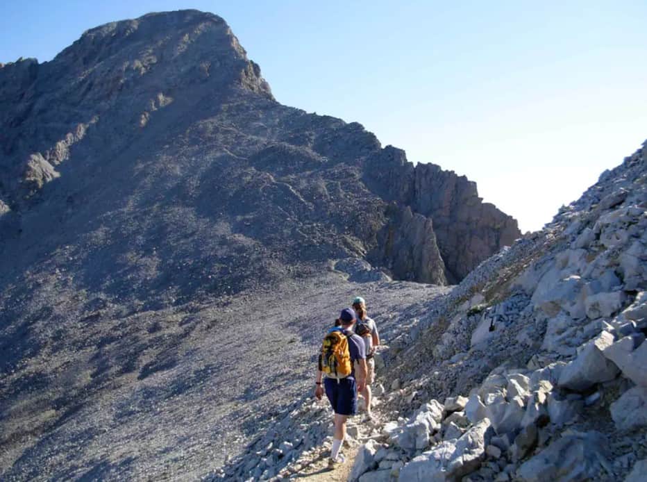
At the 1.6 mile (2.6 km) mark, the treeline ends. From here on, you will be scrambling with your hands and feet on a series of ridges all the way to the summit.
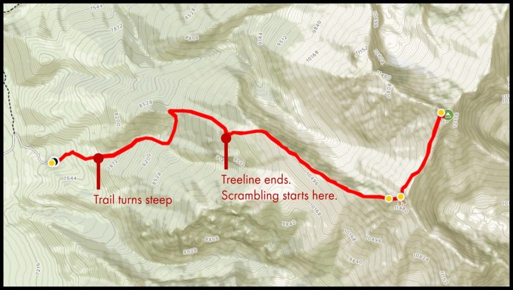
Distance: 2.7 mile to 2.9 mile (4.3 km to 4.7 km)
Elevation: 11,200 feet to 11,700 feet (3,410 m to 3,570 m)
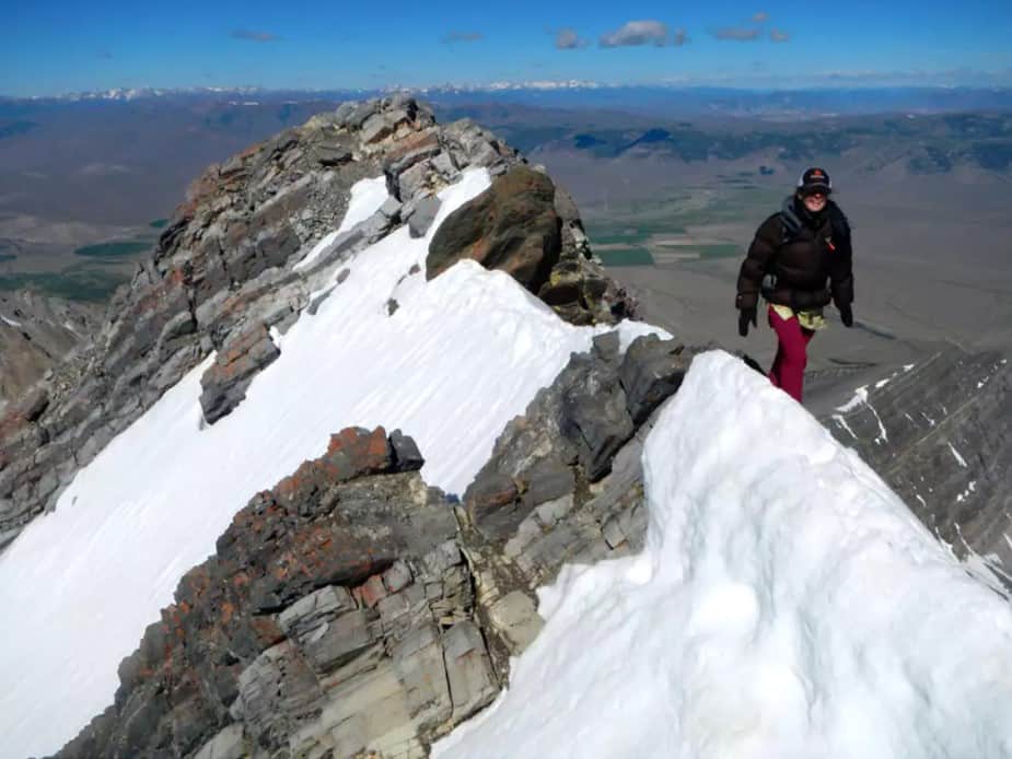
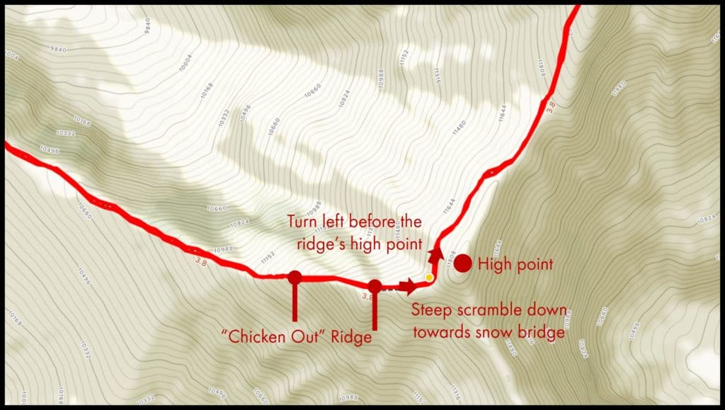
At the 2.7 mile (4.3 km) mark, you have reached the famed Chicken Out section of the climb. The Chicken Out Ridge is only a 0.2 mile section. But the ridge is highly exposed here with 2,000 ft (610 m) drops on either side.
Generally, the rocks are stable and solid. You shouldn’t have a problem finding decent footholds and handholds. Take your time to cross the section.
If you are not confident about crossing the ridge, you should turn around. This is the only way to the summit. Remember that you have to return along this same path.
Get a preview here and see if you can survive it!
Distance: 2.9 mile to 3.1 mile (4.7 km to 5 km)
Elevation: 11,700 feet to 11,750 feet (3,570 m to 3,580 m)
And just when you thought you have survived the worst, more challenges lie ahead.
Despite the infamy of the Chicken Out ridge, the last section to the summit is, in fact, more challenging.
At the end of the Chicken Out ridge is a steep scramble down to the next ridge.
You will then see the “snow bridge”. This is a section of the ridge is covered in snow and ice. It is the most dangerous section on the trail. Some climbers may choose to rope up for safety.
Beyond this section, the trail turns to the left (north). This turn is just before the high point of the ridge.
Distance: 3.1 mile to 3.6 mile (5 km to 5.8 km)
Elevation: 11,750 feet to 12,662 feet (3,580 m to 3,859 m)
At the 3.1 mile mark (5 km), the trail returns to the crest of the ridge. Follow the ridge to the summit.
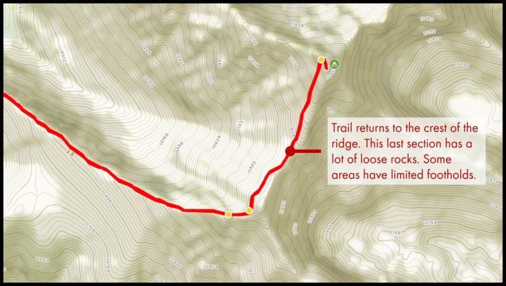
The last stretch here is quite different from the Chicken Out ridge. There are many loose rocks and you have to be very careful about where you are stepping. Some areas also do not have very good footholds.
Take your time and keep your eyes on where you are going.
Distance: 3.6 mile (5.8 km)
Elevation: 12,662 feet (3,859 m)
The summit!
What Time Should You Start Climbing (Itineraries)
Many climbers enjoy watching the sunrise on the mountain peaks. However, I would strongly advise against climbing Mount Borah in the dark. Given the narrow ridges that are over a mile long, it is crucial that you can clearly see where you are going.
There are no campsites along the trail. For an average person taking 10 to 12 hours, you will need to start off just before sunrise when the light is coming in. This will give you enough time to return to the starting point before sunset.
Typical sunrise and sunset timings:
| Sunrise | Sunset | |
| July | 5.50 am to 6.20 am | 9 pm to 9.25 pm |
| August | 6.20 am to 7 am | 8.10 pm to 9 pm |
| September | 6.55 am to 7.30 am | 7.15 pm to 8.10 pm |
Proposed Itinerary:
- Assuming an 12 hour round trip
| 6 am | Begin climb |
| 12 pm | Reach the summit |
| 12 pm — 1 pm | Lunch + take photos |
| 1 pm | Begin descent |
| 7 pm | Reach the starting point |
Do You Need A Permit? Are There Any Fees?
You don’t need to get a permit or pay any fees to climb.
If you are planning to camp at the trailhead, there is a camping fee of $5 per night for each campsite.
What To Wear
- Hat/ cap: You will be spending a lot of time directly under the sun with no trees for shelter.
- Sunglasses
- Inner layer
- Sweat-wicking shirt
- Trek pants or gym pants
- Insulating layer
- A jacket for keeping warm — can be fleece or down etc
- If you like to keep your leg warms, you can also consider bringing another layer
- Waterproof layer
- The weather is unpredictable in the mountains. Always pack a set of waterproof jacket and pants for your climb.
.
| Insider tip: Find out how to choose the right layers for your climb here. |
- Hiking socks
- Hiking boots: This is NOT a trail that you should climb with trail runners. Trail runners will provide enough traction and support for the rocky terrains. A mid-height hiking boot is preferred here. This is a job for my trusty Merrell Moab 2 — check out my review here.
| Insider tip: You may not need your insulating or waterproof layers at the start of your climb. Pack them at the top of your backpack for easy access when you need them. Keep them in waterproof bags in case of rain. Keep an extra set of clothes in your car. You can change out of your wet or sweaty clothes after your climb. |
If you are climbing outside of the July to September period, you will expect more snow in the mountains. Depending on the actual conditions, you will also need:
- Insulated footwear: You need boots with proper insulation for the weather
- Gaitors: These prevent snow or ice from getting into your boots.
- Crampons: You will need these for winter climbing.
Packing List And What To Bring
- Backpack: You will need a 25L to 30L backpack. Use a proper hiking backpack with a hip belt and padding on the shoulder straps. This will make your hike a much more comfortable one. You can see a review of my favorite 30L backpack here.
- Extra set of clothes (you can leave them in the car)
- Hiking stick: Not particularly useful here. You need to use your hands on the steeper of the trails. But it may be useful along certain sections when you are coming down from the summit. It helps with your balance and reduces the impact on your knees. Check out these tips on climbing with painful or injured knees.
- Headlamp: In case your climb took longer than expected. Do not rely on a torchlight or your phone. You should keep your hands free during the climb.
- Water: Depending on your needs, I recommend at least 0.5 to 0.8 gallons (2 to 3 liters) of water.
- Food: Depending on the duration of your climb, you will need to pack some snacks or even a proper meal or two. Get some ideas on what food and snacks you can pack for your trip. You need to bring more food if you are climbing in winter.
- First aid supplies: I always have these items with me
- Plasters
- Eyedrops: In case sand or debris get into your eyes
- Medication for headaches, nausea, stomach upset, altitude sickness etc
- Insect repellent, ointments for insect bites
- Nail clippers: For some reason, my fingernails tend to chip or crack in the mountains
- Trash bags: There are no trash bins in the mountains. Everything that you carry in with you has to come out with you.
- Camera: You don’t want to be climbing to the top of Idaho and not have something to capture the amazing views! This is my favorite camera that’s easy to bring on a trail.
- Miscellaneous
- Sunblock
- Lip balm
- Tissue, napkins, toilet paper
- Hand sanitizer
- Whistle: Useful for an emergency, especially if you are climbing alone.
- Hand and foot warmers: Useful if you do not do well in cold temperatures.
If you are camping overnight, you will also need:
- Sleeping bag: Make sure it is sufficiently insulated for the weather.
- Sleeping aids: If you are a light sleeper, it helps to wear an eye mask or earplugs when you sleep.
- Pocketknife: Useful for general camping needs.
For winter climbs, you will need:
- Ice axe: Ice axe is required when crossing snowfields. They are used to cut steps in hard snow or ice. They are also used for self-arrest (i.e. stopping your fall). Learn more about self-arrests and check out my favorite ice axe here.
- Avalanche safety gear such as snow shovel and snow probe.
| Insider tips: – To protect your stuff from the rain, pack them in small waterproof bags in your backpack. At a minimum, make sure you waterproof your electronics such as phones and cameras. I like to use ziplock bags for this. – Ziplock bags also double up as spill proof trash bags. These are perfect for storing food or other messy waste. |
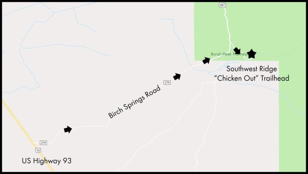
How To Get To The Southwest Ridge “Chicken Out” Trailhead?
From US Highway 93, turn into Birch Springs Road. This is a 3 mile (4.8 km) long road that leads all the way to the parking lot and trailhead.
Birch Springs Road can be accessed by all cars.
Trailhead coordiantes:
44°07’56.9″N 113°50’04.4″W
44.132480, -113.834547
| Insider tips: – If you are using Google Maps or other navigation on your phone, download an offline map in case you lose cell reception. – You can check for road closures and the current road conditions here. |
Locations Of Parking Lots
There is 1 parking area for the Southwest Ridge “Chicken Out” Trailhead.
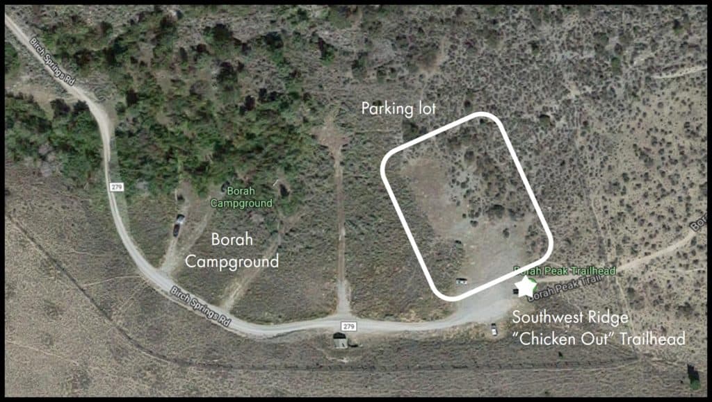
The parking lot can fit about 50 to 60 cars. The parking area does not have any bathroom. The closest bathroom is at the Borah Campground which is about 500 feet (150 m) back down Birch Springs Road.
There is no drinking water at the trailhead nor at the campground.
Parking lot coordinates:
44°07’56.9″N 113°50’05.1″W
44.132479, -113.834753
Camping And Accommodation
There is a small campground just before the parking lot.
Borah Campground
Borah campground only has 5 campsites here. There are bathrooms and informational signs. But there is no drinking water.
The fees are $5 per night for 1 single campsite. The campsite is open from mid-May. There are no reservations for the campsites. They are on a first-come-first-served basis.
You can see the map and the campsite rules here.
Borah Campground coordinates
44°07’57.6″N 113°50’10.7″W
44.132657, -113.836298
| Insider tip: With only 5 campsites around, it may be difficult to secure a spot. If you would still like to spend the night close to the trailhead, you can consider sleeping in your car at the parking lot. Alternatively, you can stay at Mackay and drive to the trailhead in the early morning. |
Climbing Mount Borah In Winter: A Recap And Important Things to Note
Always check the latest alerts and notices from the Salmon-Challis National Forest.
- Avalanches are possible. Check the latest forecast here.
- Winter climbing is suited for more experienced climbers. All winter climbs here are technical climbs. Beginners should not attempt to climb Mount Borah in winter.
- Expect longer climb times in the winter.
- Make sure you have additional insulating layers for your climb.
- You need winter gear such as gaiters, microspikes/ crampons, and even an ice axe.
- You may also need avalanche safety gear such as a snow shovel and snow probe. Learn how to use these pieces of equipment properly before your climb.
- You need to bring extra food.
- If you are camping, make sure your sleeping bag has sufficient insulation.
- The daylight hours are shorter in winter. Make sure you bring along your headlamps to avoid getting stuck in the dark.
- The trails may be hidden by the snow or ice. Make sure you are familiar with route finding (i.e. how to read a map and use a compass or GPS).
- There are fewer climbers in winter. Do not expect to bump into other climbers if you are lost or need assistance.
What Are The Dangers Of Climbing Mount Borah?
Mount Borah is a challenging and physically demanding climb. There are many dangers and risks involved:
- Falls: A high risk on Mount Borah. About a third of the trail involves scrambling on narrow ridges. There are loose rocks and snow and ice on these ridges. The ridges are highly exposed, with deadly drops on either side. Being a volcanic mountain, many parts of the trails have loose rocks on steep terrains. There are snow and ice even in summer. Hiking over loose rocks and snowfields greatly increase your chances of falling.
- Hypothermia: A serious risk in winter and even in the summer if you are not adequately dressed!
- Altitude sickness
- Dehydration: It is a long day climb. Do not underestimate how much water you need.
- Getting lost: A bigger risk when the trails are covered by snow or ice.
- Avalanches: A risk in winter.
These are just a few of the hazards you may encounter. To find out more about these dangers and how to prevent them, check out this article.
Other Important Information
- There is no drinking water at the trailhead or along the trail. Ensure that you have brought sufficient water for a full day’s hike.
- There are no restrictions about bringing dogs on the trail. However, it is unlikely that dogs can safely cross the ridges on the trail. They may end up endangering themselves or other people.
This is Part 6 of 6 of the Mountains To Climb In The US Mini-series:
Part 1: Highest Mountains To Climb In The US For Beginners
Part 2: Ultimate Guide To Climbing Mount Elbert
Part 3: Ultimate Guide To Climbing Mount Katahdin
Part 4: Ultimate Guide To Climbing Mount Bierstadt
Part 5: Ultimate Guide To Climbing South Sister
Part 6: Ultimate Guide To Climbing Mount Borah
Save to Pinterest and add this to your bucket list!